نشانی: 3300 (From 3300 To 3399) HIGHWAY 71, BRAYTON, IA 50042-7522, USA
؟50042-7522 چیست 50042-7522 یک کد فشرده 5 به همراه 4 عدد از 3300 (From 3300 To 3399) HIGHWAY 71, BRAYTON, IA, USA است. اطلاعات بیشتر در زیر آمده است.
50042-7522 اطلاعات اولیه

-
کد پستی 5 به علاوه 4:
50042-7522 -
کد پستی 5:
50042 -
به علاوه 4?75224-digits that are used to identify a geographic segment within the 5-digit delivery area, such as a city block or a group of apartments or an individual high-volume receiver of mail, or any other unit that could use an extra identifier to aid in efficient mail sorting and delivery. This code is the low end of the range of +4 Codes that pertain to this ZIP Code. ZIP+4 Codes associated with nondelivery areas are composed of valid ZIP sector numbers and "ND" for the ZIP segment number, for example 12345-12ND. Non-deliverable areas are areas to which the USPS does not deliver mail, such as vacant lots and land that borders railroad tracks. Mailers should not match an address identified as a nondelivery area. If you absolutely must have numeric characters in the Plus4Code column, you may treat "ND" values as "00" (zero zero).:
-
کشور:
U.S. - ایالات متحده -
دولت:
IA - آیووا -
شهرستان:
CountyFIPS: 19009 - Audubon County -
شهر:
BRAYTON -
خیابان?HIGHWAY 71The official name of a street as assigned by a local governing authority. The Street Name column contains only the street name and does not include directionals (EAST, WEST, etc.) or suffixes (ST, DR, BLVD, etc.). This element may also contain literals, such as PO BOX, GENERAL DELIVERY, USS, PSC, or UNIT. Numeric street names that have numeric components that are four characters (or less) in length at are justified such that the low-order digit of the number is positioned in the fourth position of the street name column. This shift is made so that the numeric street names appear in numeric sequence.:
-
نوع ثبت?S: خیابانAn alphabetic value that identifies the type of data in the record. Record type codes include the following: G = General delivery H = Highrise F = Firm S = Street P = PO box R = Rural route/highway contract:
نشانی

- شماره پایین آدرس اولیه?
A house, rural route, highway contract box, or post office box number; the numeric or alphanumeric component of an address preceding the street name; the low-end address in a range of addresses. Often referred to as house number.: 3300
- شماره بالا آدرس اولیه?
A house, rural route, contract box, or Post Office box number. The numeric or alphanumeric component of an address preceding the street name. The high-end address in a range of addresses. Often referred to as house number.: 3399
- کد فرد/ زوج آدرس اولیه?
Code that identifies the side or sides of a street for which a given address range is applicable. For street, highrise, firm and multi-carrier records, B = Both sides of a street, E = Even side of a street (even-numbered addresses in the range); O = Odd side of a street (odd-numbered addresses in the range). For general delivery, post office box, and rural route/highway contract records, this code will always be "B" (both).: Both of Odd and Even
- اولیه محدوده: 3300, 3301, 3302, 3303, 3304, 3305, 3306, 3307, 3308, 3309, 3310, 3311, 3312, 3313, 3314, 3315, 3316, 3317, 3318, 3319, 3320, 3321, 3322, 3323, 3324, 3325, 3326, 3327, 3328, 3329, 3330, 3331, 3332, 3333, 3334, 3335, 3336, 3337, 3338, 3339, 3340, 3341, 3342, 3343, 3344, 3345, 3346, 3347, 3348, 3349, 3350, 3351, 3352, 3353, 3354, 3355, 3356, 3357, 3358, 3359, 3360, 3361, 3362, 3363, 3364, 3365, 3366, 3367, 3368, 3369, 3370, 3371, 3372, 3373, 3374, 3375, 3376, 3377, 3378, 3379, 3380, 3381, 3382, 3383, 3384, 3385, 3386, 3387, 3388, 3389, 3390, 3391, 3392, 3393, 3394, 3395, 3396, 3397, 3398, 3399.
لطفاً برای مشاهده کل لیست ، بر روی "نمونه های آدرس بیشتر" کلیک کنید.
3300 HIGHWAY 71, BRAYTON, IA 50042-7522
3301 HIGHWAY 71, BRAYTON, IA 50042-7522
3302 HIGHWAY 71, BRAYTON, IA 50042-7522
3303 HIGHWAY 71, BRAYTON, IA 50042-7522
3304 HIGHWAY 71, BRAYTON, IA 50042-7522
3305 HIGHWAY 71, BRAYTON, IA 50042-7522
3306 HIGHWAY 71, BRAYTON, IA 50042-7522
3307 HIGHWAY 71, BRAYTON, IA 50042-7522
3308 HIGHWAY 71, BRAYTON, IA 50042-7522
3309 HIGHWAY 71, BRAYTON, IA 50042-7522
3310 HIGHWAY 71, BRAYTON, IA 50042-7522
3311 HIGHWAY 71, BRAYTON, IA 50042-7522
3312 HIGHWAY 71, BRAYTON, IA 50042-7522
3313 HIGHWAY 71, BRAYTON, IA 50042-7522
3314 HIGHWAY 71, BRAYTON, IA 50042-7522
3315 HIGHWAY 71, BRAYTON, IA 50042-7522
3316 HIGHWAY 71, BRAYTON, IA 50042-7522
3317 HIGHWAY 71, BRAYTON, IA 50042-7522
3318 HIGHWAY 71, BRAYTON, IA 50042-7522
3319 HIGHWAY 71, BRAYTON, IA 50042-7522
3320 HIGHWAY 71, BRAYTON, IA 50042-7522
3321 HIGHWAY 71, BRAYTON, IA 50042-7522
3322 HIGHWAY 71, BRAYTON, IA 50042-7522
3323 HIGHWAY 71, BRAYTON, IA 50042-7522
3324 HIGHWAY 71, BRAYTON, IA 50042-7522
3325 HIGHWAY 71, BRAYTON, IA 50042-7522
3326 HIGHWAY 71, BRAYTON, IA 50042-7522
3327 HIGHWAY 71, BRAYTON, IA 50042-7522
3328 HIGHWAY 71, BRAYTON, IA 50042-7522
3329 HIGHWAY 71, BRAYTON, IA 50042-7522
3330 HIGHWAY 71, BRAYTON, IA 50042-7522
3331 HIGHWAY 71, BRAYTON, IA 50042-7522
3332 HIGHWAY 71, BRAYTON, IA 50042-7522
3333 HIGHWAY 71, BRAYTON, IA 50042-7522
3334 HIGHWAY 71, BRAYTON, IA 50042-7522
3335 HIGHWAY 71, BRAYTON, IA 50042-7522
3336 HIGHWAY 71, BRAYTON, IA 50042-7522
3337 HIGHWAY 71, BRAYTON, IA 50042-7522
3338 HIGHWAY 71, BRAYTON, IA 50042-7522
3339 HIGHWAY 71, BRAYTON, IA 50042-7522
3340 HIGHWAY 71, BRAYTON, IA 50042-7522
3341 HIGHWAY 71, BRAYTON, IA 50042-7522
3342 HIGHWAY 71, BRAYTON, IA 50042-7522
3343 HIGHWAY 71, BRAYTON, IA 50042-7522
3344 HIGHWAY 71, BRAYTON, IA 50042-7522
3345 HIGHWAY 71, BRAYTON, IA 50042-7522
3346 HIGHWAY 71, BRAYTON, IA 50042-7522
3347 HIGHWAY 71, BRAYTON, IA 50042-7522
3348 HIGHWAY 71, BRAYTON, IA 50042-7522
3349 HIGHWAY 71, BRAYTON, IA 50042-7522
3350 HIGHWAY 71, BRAYTON, IA 50042-7522
3351 HIGHWAY 71, BRAYTON, IA 50042-7522
3352 HIGHWAY 71, BRAYTON, IA 50042-7522
3353 HIGHWAY 71, BRAYTON, IA 50042-7522
3354 HIGHWAY 71, BRAYTON, IA 50042-7522
3355 HIGHWAY 71, BRAYTON, IA 50042-7522
3356 HIGHWAY 71, BRAYTON, IA 50042-7522
3357 HIGHWAY 71, BRAYTON, IA 50042-7522
3358 HIGHWAY 71, BRAYTON, IA 50042-7522
3359 HIGHWAY 71, BRAYTON, IA 50042-7522
3360 HIGHWAY 71, BRAYTON, IA 50042-7522
3361 HIGHWAY 71, BRAYTON, IA 50042-7522
3362 HIGHWAY 71, BRAYTON, IA 50042-7522
3363 HIGHWAY 71, BRAYTON, IA 50042-7522
3364 HIGHWAY 71, BRAYTON, IA 50042-7522
3365 HIGHWAY 71, BRAYTON, IA 50042-7522
3366 HIGHWAY 71, BRAYTON, IA 50042-7522
3367 HIGHWAY 71, BRAYTON, IA 50042-7522
3368 HIGHWAY 71, BRAYTON, IA 50042-7522
3369 HIGHWAY 71, BRAYTON, IA 50042-7522
3370 HIGHWAY 71, BRAYTON, IA 50042-7522
3371 HIGHWAY 71, BRAYTON, IA 50042-7522
3372 HIGHWAY 71, BRAYTON, IA 50042-7522
3373 HIGHWAY 71, BRAYTON, IA 50042-7522
3374 HIGHWAY 71, BRAYTON, IA 50042-7522
3375 HIGHWAY 71, BRAYTON, IA 50042-7522
3376 HIGHWAY 71, BRAYTON, IA 50042-7522
3377 HIGHWAY 71, BRAYTON, IA 50042-7522
3378 HIGHWAY 71, BRAYTON, IA 50042-7522
3379 HIGHWAY 71, BRAYTON, IA 50042-7522
3380 HIGHWAY 71, BRAYTON, IA 50042-7522
3381 HIGHWAY 71, BRAYTON, IA 50042-7522
3382 HIGHWAY 71, BRAYTON, IA 50042-7522
3383 HIGHWAY 71, BRAYTON, IA 50042-7522
3384 HIGHWAY 71, BRAYTON, IA 50042-7522
3385 HIGHWAY 71, BRAYTON, IA 50042-7522
3386 HIGHWAY 71, BRAYTON, IA 50042-7522
3387 HIGHWAY 71, BRAYTON, IA 50042-7522
3388 HIGHWAY 71, BRAYTON, IA 50042-7522
3389 HIGHWAY 71, BRAYTON, IA 50042-7522
3390 HIGHWAY 71, BRAYTON, IA 50042-7522
3391 HIGHWAY 71, BRAYTON, IA 50042-7522
3392 HIGHWAY 71, BRAYTON, IA 50042-7522
3393 HIGHWAY 71, BRAYTON, IA 50042-7522
3394 HIGHWAY 71, BRAYTON, IA 50042-7522
3395 HIGHWAY 71, BRAYTON, IA 50042-7522
3396 HIGHWAY 71, BRAYTON, IA 50042-7522
3397 HIGHWAY 71, BRAYTON, IA 50042-7522
3398 HIGHWAY 71, BRAYTON, IA 50042-7522
3399 HIGHWAY 71, BRAYTON, IA 50042-7522
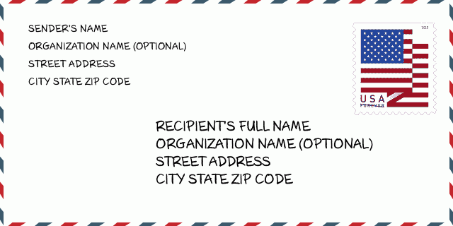
نشانی مثال
BRAYTON IA 50042-7522
UNITED STATES OF AMERICA
50042-7522 نمونه پاکت

-
این نمونه ای از پاکت نامه ایالات متحده است. اطلاعات فرستنده را در بالا سمت چپ و اطلاعات گیرنده را در پایین سمت راست وارد کنید. اطلاعات لازم نام کامل فرستنده/گیرنده ، آدرس خیابان ، شهر ، ایالت و کد پستی است. اطلاعات آدرس گیرنده برای مرجع شما داده شده است. به طور کلی ، اگر از کد پستی کامل 9 رقمی مطمئن نیستید ، فقط می توانید کد پستی 5 رقمی را پر کنید تا از دست دادن بسته جلوگیری شود.
50042-7522 معنای اساسی
-
هر رقم کد پستی 50042-7522 مخفف چیست؟ کد ZIP+4 از دو بخش تشکیل شده است، پنج رقم اول را می توان در اداره پست قرار داد، و چهار رقم آخر می تواند یک بخش جغرافیایی را در منطقه تحویل پنج رقمی مشخص کند. 6-7 رقم بخش یا چند بلوک را مشخص می کند و رقم 8-9 نشان دهنده بخش یا یک طرف خیابان است.
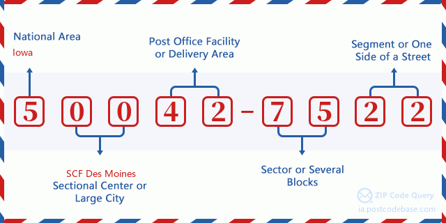

- ·شناسایی مسیر حامل?
A 4-digit code assigned to a mail delivery or collection route within a 5-digit ZIP Code. The first character of this identification is alphabetical, and the last three are numeric: Bnnn = PO box Hnnn = Highway contract Rnnn = Rural route Cnnn = City delivery Gnnn = General delivery: R001 (مسیر روستایی)
- ·بخش پایین افزونه فشرده?
The ZIP Add-On Low Sector and the ZIP Add-On Low Segment together form the ZIP Add-On Low Number. The ZIP Add-On Low Number is the last four positions of a ZIP+4 code; the low-end ZIP add-on in a range of codes; the add-on of the first ZIP+4 code in a consecutive series of ZIP+4 codes assigned to the delivery address. For example, most delivery addresses are assigned a single ZIP+4 code. However, large companies may be given a range of ZIP+4 codes that can be used to route mail to specific departments. A range of ZIP+4 codes can also be assigned to a corresponding range of post office boxes, and each box is mapped, one-to-one, with a ZIP+4 code in the range. A single post office box can also be assigned a range of ZIP+4 codes.: 75
- ·بخش پایین افزونه فشرده?
The ZIP Add-On Low Sector and the ZIP Add-On Low Segment together form the ZIP Add-On Low Number. The ZIP Add-On Low Number is the last four positions of a ZIP+4 code; the low-end ZIP add-on in a range of codes; the add-on of the first ZIP+4 code in a consecutive series of ZIP+4 codes assigned to the delivery address. For example, most delivery addresses are assigned a single ZIP+4 code. However, large companies may be given a range of ZIP+4 codes that can be used to route mail to specific departments. A range of ZIP+4 codes can also be assigned to a corresponding range of post office boxes, and each box is mapped, one-to-one, with a ZIP+4 code in the range. A single post office box can also be assigned a range of ZIP+4 codes.: 22
- ·بخش بالا افزونه فشرده?
The ZIP Add-On High Sector and the ZIP Add-On High Segment together form the ZIP Add-On High Number, which is the high-end ZIP add-on in a range of codes; the add-on of the last ZIP+4 code in a consecutive series of ZIP+4 codes assigned to the delivery address. Most delivery addresses are assigned a single ZIP+4 code; however, large companies may be given a range of ZIP+4 codes that can be used to route mail to specific departments. A range of ZIP+4 codes can also be assigned to a corresponding range of post office boxes, and each box is mapped, one-to-one, with a ZIP+4 code in the range. A single post office box can also be assigned a range of ZIP+4 codes. (See also ZIP Add-On Code.): 75
- ·بخش بالا افزونه فشرده?
The ZIP Add-On High Sector and the ZIP Add-On High Segment together form the ZIP Add-On High Number, which is the high-end ZIP add-on in a range of codes; the add-on of the last ZIP+4 code in a consecutive series of ZIP+4 codes assigned to the delivery address. Most delivery addresses are assigned a single ZIP+4 code; however, large companies may be given a range of ZIP+4 codes that can be used to route mail to specific departments. A range of ZIP+4 codes can also be assigned to a corresponding range of post office boxes, and each box is mapped, one-to-one, with a ZIP+4 code in the range. A single post office box can also be assigned a range of ZIP+4 codes. (See also ZIP Add-On Code.): 22
- ·کد پستی افزونه: 7522
- ·محدوده?
The range of +4 codes. Summing the +4 Code and the +4 Range will give you the high end of the range of +4 Codes that pertain to this ZIP Code.: 0
- ·کد متناوب پایه?
Code that specifies whether a record is a base (preferred) or alternate record. Base records (represented as "B") can represent a range of addresses or an individual address, such as a firm record, while alternate records (represented as "A") are individual delivery points. Government deliveries will only be listed on alternate records with the appropriate government building indicator (federal, state, or city) set.: پایه
- ·شماره مالی?
A code assigned to Postal Service facilities (primarily post offices) to collect cost and statistical data and compile revenue and expense data. The state number comprises the first two positions of the finance number.: 181080
- ·شماره ناحیه کنگره?
A standard value identifying a geographic area within the United States served by a member of the US House of Representatives or Senate. If Army/Air Force (APO) or fleet post office (FPO), this column will be blank. If there is only one member of Congress within a state, the code will be "AL" (at large).: 05
- ·کلید دولتی خط نهایی ترجیحی?
An index to the City State file that provides the preferred last-line name for this address range.: W10166
نقشه آنلاین

این نقشه آنلاین آدرس 3300 HIGHWAY 71 BRAYTON است. برای حرکت و زوم میتوانید از دکمه استفاده کنید. اطلاعات نقشه تنها برای مرجع است.
نشانی: 3300 (From 3300 To 3399) HIGHWAY 71, BRAYTON, IA 50042-7522, USA
دیدگاه


افزودن دیدگاه جدید