アドレス: 500 (From 500 To 599) COUNTY LINE AVE, ADAIR, IA 50002-1030, USA
50002-1030とは? 50002-1030 500 (From 500 To 599) COUNTY LINE AVE, ADAIR, IA, USA の5桁郵便番号に4桁をプラスした番号である。以下は詳細情報である。
50002-1030基本情報

-
郵便番号5プラス4:
50002-1030 -
郵便番号5:
50002 -
プラス4?10304-digits that are used to identify a geographic segment within the 5-digit delivery area, such as a city block or a group of apartments or an individual high-volume receiver of mail, or any other unit that could use an extra identifier to aid in efficient mail sorting and delivery. This code is the low end of the range of +4 Codes that pertain to this ZIP Code. ZIP+4 Codes associated with nondelivery areas are composed of valid ZIP sector numbers and "ND" for the ZIP segment number, for example 12345-12ND. Non-deliverable areas are areas to which the USPS does not deliver mail, such as vacant lots and land that borders railroad tracks. Mailers should not match an address identified as a nondelivery area. If you absolutely must have numeric characters in the Plus4Code column, you may treat "ND" values as "00" (zero zero).:
-
国:
U.S. - 米国 -
州:
IA - アイオワ州 -
郡:
CountyFIPS: 19001 - Adair County -
市:
ADAIR -
ストリート?COUNTY LINE AVEThe official name of a street as assigned by a local governing authority. The Street Name column contains only the street name and does not include directionals (EAST, WEST, etc.) or suffixes (ST, DR, BLVD, etc.). This element may also contain literals, such as PO BOX, GENERAL DELIVERY, USS, PSC, or UNIT. Numeric street names that have numeric components that are four characters (or less) in length at are justified such that the low-order digit of the number is positioned in the fourth position of the street name column. This shift is made so that the numeric street names appear in numeric sequence.:
-
ストリートサフィックス?AVE (大通り)The street suffix: For Example: ST = Street RD = Road DR = Drive LN = Lane:
-
レコード形式?S: ストリートAn alphabetic value that identifies the type of data in the record. Record type codes include the following: G = General delivery H = Highrise F = Firm S = Street P = PO box R = Rural route/highway contract:
アドレス

- 主な住所の低い数値?
A house, rural route, highway contract box, or post office box number; the numeric or alphanumeric component of an address preceding the street name; the low-end address in a range of addresses. Often referred to as house number.: 500
- 主な住所の高い数値?
A house, rural route, contract box, or Post Office box number. The numeric or alphanumeric component of an address preceding the street name. The high-end address in a range of addresses. Often referred to as house number.: 599
- 主な住所の偶数/奇数コード?
Code that identifies the side or sides of a street for which a given address range is applicable. For street, highrise, firm and multi-carrier records, B = Both sides of a street, E = Even side of a street (even-numbered addresses in the range); O = Odd side of a street (odd-numbered addresses in the range). For general delivery, post office box, and rural route/highway contract records, this code will always be "B" (both).: Both of Odd and Even
- プライマリ範囲: 500, 501, 502, 503, 504, 505, 506, 507, 508, 509, 510, 511, 512, 513, 514, 515, 516, 517, 518, 519, 520, 521, 522, 523, 524, 525, 526, 527, 528, 529, 530, 531, 532, 533, 534, 535, 536, 537, 538, 539, 540, 541, 542, 543, 544, 545, 546, 547, 548, 549, 550, 551, 552, 553, 554, 555, 556, 557, 558, 559, 560, 561, 562, 563, 564, 565, 566, 567, 568, 569, 570, 571, 572, 573, 574, 575, 576, 577, 578, 579, 580, 581, 582, 583, 584, 585, 586, 587, 588, 589, 590, 591, 592, 593, 594, 595, 596, 597, 598, 599.
リスト全体を表示するには、"その他の住所の例"をクリックしてください。
500 COUNTY LINE AVE, ADAIR, IA 50002-1030
501 COUNTY LINE AVE, ADAIR, IA 50002-1030
502 COUNTY LINE AVE, ADAIR, IA 50002-1030
503 COUNTY LINE AVE, ADAIR, IA 50002-1030
504 COUNTY LINE AVE, ADAIR, IA 50002-1030
505 COUNTY LINE AVE, ADAIR, IA 50002-1030
506 COUNTY LINE AVE, ADAIR, IA 50002-1030
507 COUNTY LINE AVE, ADAIR, IA 50002-1030
508 COUNTY LINE AVE, ADAIR, IA 50002-1030
509 COUNTY LINE AVE, ADAIR, IA 50002-1030
510 COUNTY LINE AVE, ADAIR, IA 50002-1030
511 COUNTY LINE AVE, ADAIR, IA 50002-1030
512 COUNTY LINE AVE, ADAIR, IA 50002-1030
513 COUNTY LINE AVE, ADAIR, IA 50002-1030
514 COUNTY LINE AVE, ADAIR, IA 50002-1030
515 COUNTY LINE AVE, ADAIR, IA 50002-1030
516 COUNTY LINE AVE, ADAIR, IA 50002-1030
517 COUNTY LINE AVE, ADAIR, IA 50002-1030
518 COUNTY LINE AVE, ADAIR, IA 50002-1030
519 COUNTY LINE AVE, ADAIR, IA 50002-1030
520 COUNTY LINE AVE, ADAIR, IA 50002-1030
521 COUNTY LINE AVE, ADAIR, IA 50002-1030
522 COUNTY LINE AVE, ADAIR, IA 50002-1030
523 COUNTY LINE AVE, ADAIR, IA 50002-1030
524 COUNTY LINE AVE, ADAIR, IA 50002-1030
525 COUNTY LINE AVE, ADAIR, IA 50002-1030
526 COUNTY LINE AVE, ADAIR, IA 50002-1030
527 COUNTY LINE AVE, ADAIR, IA 50002-1030
528 COUNTY LINE AVE, ADAIR, IA 50002-1030
529 COUNTY LINE AVE, ADAIR, IA 50002-1030
530 COUNTY LINE AVE, ADAIR, IA 50002-1030
531 COUNTY LINE AVE, ADAIR, IA 50002-1030
532 COUNTY LINE AVE, ADAIR, IA 50002-1030
533 COUNTY LINE AVE, ADAIR, IA 50002-1030
534 COUNTY LINE AVE, ADAIR, IA 50002-1030
535 COUNTY LINE AVE, ADAIR, IA 50002-1030
536 COUNTY LINE AVE, ADAIR, IA 50002-1030
537 COUNTY LINE AVE, ADAIR, IA 50002-1030
538 COUNTY LINE AVE, ADAIR, IA 50002-1030
539 COUNTY LINE AVE, ADAIR, IA 50002-1030
540 COUNTY LINE AVE, ADAIR, IA 50002-1030
541 COUNTY LINE AVE, ADAIR, IA 50002-1030
542 COUNTY LINE AVE, ADAIR, IA 50002-1030
543 COUNTY LINE AVE, ADAIR, IA 50002-1030
544 COUNTY LINE AVE, ADAIR, IA 50002-1030
545 COUNTY LINE AVE, ADAIR, IA 50002-1030
546 COUNTY LINE AVE, ADAIR, IA 50002-1030
547 COUNTY LINE AVE, ADAIR, IA 50002-1030
548 COUNTY LINE AVE, ADAIR, IA 50002-1030
549 COUNTY LINE AVE, ADAIR, IA 50002-1030
550 COUNTY LINE AVE, ADAIR, IA 50002-1030
551 COUNTY LINE AVE, ADAIR, IA 50002-1030
552 COUNTY LINE AVE, ADAIR, IA 50002-1030
553 COUNTY LINE AVE, ADAIR, IA 50002-1030
554 COUNTY LINE AVE, ADAIR, IA 50002-1030
555 COUNTY LINE AVE, ADAIR, IA 50002-1030
556 COUNTY LINE AVE, ADAIR, IA 50002-1030
557 COUNTY LINE AVE, ADAIR, IA 50002-1030
558 COUNTY LINE AVE, ADAIR, IA 50002-1030
559 COUNTY LINE AVE, ADAIR, IA 50002-1030
560 COUNTY LINE AVE, ADAIR, IA 50002-1030
561 COUNTY LINE AVE, ADAIR, IA 50002-1030
562 COUNTY LINE AVE, ADAIR, IA 50002-1030
563 COUNTY LINE AVE, ADAIR, IA 50002-1030
564 COUNTY LINE AVE, ADAIR, IA 50002-1030
565 COUNTY LINE AVE, ADAIR, IA 50002-1030
566 COUNTY LINE AVE, ADAIR, IA 50002-1030
567 COUNTY LINE AVE, ADAIR, IA 50002-1030
568 COUNTY LINE AVE, ADAIR, IA 50002-1030
569 COUNTY LINE AVE, ADAIR, IA 50002-1030
570 COUNTY LINE AVE, ADAIR, IA 50002-1030
571 COUNTY LINE AVE, ADAIR, IA 50002-1030
572 COUNTY LINE AVE, ADAIR, IA 50002-1030
573 COUNTY LINE AVE, ADAIR, IA 50002-1030
574 COUNTY LINE AVE, ADAIR, IA 50002-1030
575 COUNTY LINE AVE, ADAIR, IA 50002-1030
576 COUNTY LINE AVE, ADAIR, IA 50002-1030
577 COUNTY LINE AVE, ADAIR, IA 50002-1030
578 COUNTY LINE AVE, ADAIR, IA 50002-1030
579 COUNTY LINE AVE, ADAIR, IA 50002-1030
580 COUNTY LINE AVE, ADAIR, IA 50002-1030
581 COUNTY LINE AVE, ADAIR, IA 50002-1030
582 COUNTY LINE AVE, ADAIR, IA 50002-1030
583 COUNTY LINE AVE, ADAIR, IA 50002-1030
584 COUNTY LINE AVE, ADAIR, IA 50002-1030
585 COUNTY LINE AVE, ADAIR, IA 50002-1030
586 COUNTY LINE AVE, ADAIR, IA 50002-1030
587 COUNTY LINE AVE, ADAIR, IA 50002-1030
588 COUNTY LINE AVE, ADAIR, IA 50002-1030
589 COUNTY LINE AVE, ADAIR, IA 50002-1030
590 COUNTY LINE AVE, ADAIR, IA 50002-1030
591 COUNTY LINE AVE, ADAIR, IA 50002-1030
592 COUNTY LINE AVE, ADAIR, IA 50002-1030
593 COUNTY LINE AVE, ADAIR, IA 50002-1030
594 COUNTY LINE AVE, ADAIR, IA 50002-1030
595 COUNTY LINE AVE, ADAIR, IA 50002-1030
596 COUNTY LINE AVE, ADAIR, IA 50002-1030
597 COUNTY LINE AVE, ADAIR, IA 50002-1030
598 COUNTY LINE AVE, ADAIR, IA 50002-1030
599 COUNTY LINE AVE, ADAIR, IA 50002-1030
アドレス例
ADAIR IA 50002-1030
UNITED STATES OF AMERICA
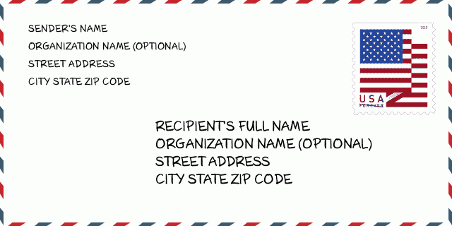
50002-1030封筒の例

-
これは米国の封筒の例です。左上に送信者の情報を入力し、右下に受信者の情報を入力します。必要な情報は、送信者/受信者の氏名、住所、都市、州、および郵便番号です。参照用に受信者のアドレス情報が提供されています。通常、完全な9桁の郵便番号がわからない場合は、パッケージの紛失を防ぐために5桁の郵便番号のみを入力できます。
50002-1030基本的な意味
-
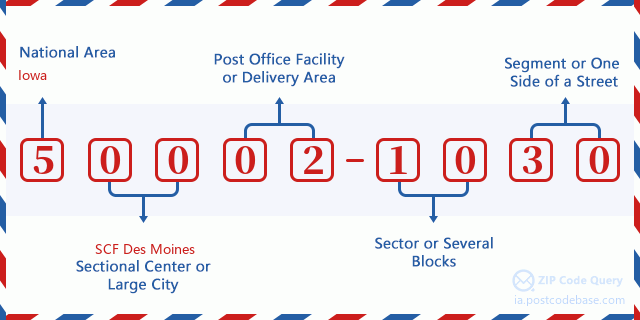
郵便番号50002-1030の各桁は何を表していますか?ZIP + 4コードは2つの部分で構成され、最初の5桁は郵便局に配置でき、最後の4桁は5桁の配達エリア内の地理的セグメントを識別できます。 6〜7桁はセクターまたは複数のブロックを示し、8〜9桁はセグメントまたは通りの片側を示します。

- ·キャリアルートの ID?
A 4-digit code assigned to a mail delivery or collection route within a 5-digit ZIP Code. The first character of this identification is alphabetical, and the last three are numeric: Bnnn = PO box Hnnn = Highway contract Rnnn = Rural route Cnnn = City delivery Gnnn = General delivery: R002 (農村配達ルート)
- ·ZIPアドオンローセクター?
The ZIP Add-On Low Sector and the ZIP Add-On Low Segment together form the ZIP Add-On Low Number. The ZIP Add-On Low Number is the last four positions of a ZIP+4 code; the low-end ZIP add-on in a range of codes; the add-on of the first ZIP+4 code in a consecutive series of ZIP+4 codes assigned to the delivery address. For example, most delivery addresses are assigned a single ZIP+4 code. However, large companies may be given a range of ZIP+4 codes that can be used to route mail to specific departments. A range of ZIP+4 codes can also be assigned to a corresponding range of post office boxes, and each box is mapped, one-to-one, with a ZIP+4 code in the range. A single post office box can also be assigned a range of ZIP+4 codes.: 10
- ·ZIPアドオンローセグメント?
The ZIP Add-On Low Sector and the ZIP Add-On Low Segment together form the ZIP Add-On Low Number. The ZIP Add-On Low Number is the last four positions of a ZIP+4 code; the low-end ZIP add-on in a range of codes; the add-on of the first ZIP+4 code in a consecutive series of ZIP+4 codes assigned to the delivery address. For example, most delivery addresses are assigned a single ZIP+4 code. However, large companies may be given a range of ZIP+4 codes that can be used to route mail to specific departments. A range of ZIP+4 codes can also be assigned to a corresponding range of post office boxes, and each box is mapped, one-to-one, with a ZIP+4 code in the range. A single post office box can also be assigned a range of ZIP+4 codes.: 30
- ·ZIPアドオンハイセクター?
The ZIP Add-On High Sector and the ZIP Add-On High Segment together form the ZIP Add-On High Number, which is the high-end ZIP add-on in a range of codes; the add-on of the last ZIP+4 code in a consecutive series of ZIP+4 codes assigned to the delivery address. Most delivery addresses are assigned a single ZIP+4 code; however, large companies may be given a range of ZIP+4 codes that can be used to route mail to specific departments. A range of ZIP+4 codes can also be assigned to a corresponding range of post office boxes, and each box is mapped, one-to-one, with a ZIP+4 code in the range. A single post office box can also be assigned a range of ZIP+4 codes. (See also ZIP Add-On Code.): 10
- ·ZIPアドオンハイセグメント?
The ZIP Add-On High Sector and the ZIP Add-On High Segment together form the ZIP Add-On High Number, which is the high-end ZIP add-on in a range of codes; the add-on of the last ZIP+4 code in a consecutive series of ZIP+4 codes assigned to the delivery address. Most delivery addresses are assigned a single ZIP+4 code; however, large companies may be given a range of ZIP+4 codes that can be used to route mail to specific departments. A range of ZIP+4 codes can also be assigned to a corresponding range of post office boxes, and each box is mapped, one-to-one, with a ZIP+4 code in the range. A single post office box can also be assigned a range of ZIP+4 codes. (See also ZIP Add-On Code.): 30
- ·郵便番号追加: 1030
- ·範囲?
The range of +4 codes. Summing the +4 Code and the +4 Range will give you the high end of the range of +4 Codes that pertain to this ZIP Code.: 0
- ·基本的な代替コード?
Code that specifies whether a record is a base (preferred) or alternate record. Base records (represented as "B") can represent a range of addresses or an individual address, such as a firm record, while alternate records (represented as "A") are individual delivery points. Government deliveries will only be listed on alternate records with the appropriate government building indicator (federal, state, or city) set.: ベース
- ·ファイナンスナンバー?
A code assigned to Postal Service facilities (primarily post offices) to collect cost and statistical data and compile revenue and expense data. The state number comprises the first two positions of the finance number.: 180036
- ·議会の地区数?
A standard value identifying a geographic area within the United States served by a member of the US House of Representatives or Senate. If Army/Air Force (APO) or fleet post office (FPO), this column will be blank. If there is only one member of Congress within a state, the code will be "AL" (at large).: 03
- ·優先最終行市州キー?
An index to the City State file that provides the preferred last-line name for this address range.: W10004
オンライン地図

これは住所500 COUNTY LINE AVE, ADAIRに対応するオンライン地図である。地図の中のボタンを利用して移動、拡大・縮小を実現できる。地図情報はただご参考にされて下さい。
アドレス: 500 (From 500 To 599) COUNTY LINE AVE, ADAIR, IA 50002-1030, USA
コメント


コメントを追加