アドレス: 13200 (From 13200 To 13299) 170TH ST, DAWSON, IA 50066-4442, USA
50066-4442とは? 50066-4442 13200 (From 13200 To 13299) 170TH ST, DAWSON, IA, USA の5桁郵便番号に4桁をプラスした番号である。以下は詳細情報である。
50066-4442基本情報

-
郵便番号5プラス4:
50066-4442 -
郵便番号5:
50066 -
プラス4?44424-digits that are used to identify a geographic segment within the 5-digit delivery area, such as a city block or a group of apartments or an individual high-volume receiver of mail, or any other unit that could use an extra identifier to aid in efficient mail sorting and delivery. This code is the low end of the range of +4 Codes that pertain to this ZIP Code. ZIP+4 Codes associated with nondelivery areas are composed of valid ZIP sector numbers and "ND" for the ZIP segment number, for example 12345-12ND. Non-deliverable areas are areas to which the USPS does not deliver mail, such as vacant lots and land that borders railroad tracks. Mailers should not match an address identified as a nondelivery area. If you absolutely must have numeric characters in the Plus4Code column, you may treat "ND" values as "00" (zero zero).:
-
国:
U.S. - 米国 -
州:
IA - アイオワ州 -
郡:
CountyFIPS: 19049 - Dallas County -
市:
DAWSON -
ストリート?170TH STThe official name of a street as assigned by a local governing authority. The Street Name column contains only the street name and does not include directionals (EAST, WEST, etc.) or suffixes (ST, DR, BLVD, etc.). This element may also contain literals, such as PO BOX, GENERAL DELIVERY, USS, PSC, or UNIT. Numeric street names that have numeric components that are four characters (or less) in length at are justified such that the low-order digit of the number is positioned in the fourth position of the street name column. This shift is made so that the numeric street names appear in numeric sequence.:
-
ストリートサフィックス?ST (ストリート)The street suffix: For Example: ST = Street RD = Road DR = Drive LN = Lane:
-
レコード形式?S: ストリートAn alphabetic value that identifies the type of data in the record. Record type codes include the following: G = General delivery H = Highrise F = Firm S = Street P = PO box R = Rural route/highway contract:
アドレス

- 主な住所の低い数値?
A house, rural route, highway contract box, or post office box number; the numeric or alphanumeric component of an address preceding the street name; the low-end address in a range of addresses. Often referred to as house number.: 13200
- 主な住所の高い数値?
A house, rural route, contract box, or Post Office box number. The numeric or alphanumeric component of an address preceding the street name. The high-end address in a range of addresses. Often referred to as house number.: 13299
- 主な住所の偶数/奇数コード?
Code that identifies the side or sides of a street for which a given address range is applicable. For street, highrise, firm and multi-carrier records, B = Both sides of a street, E = Even side of a street (even-numbered addresses in the range); O = Odd side of a street (odd-numbered addresses in the range). For general delivery, post office box, and rural route/highway contract records, this code will always be "B" (both).: Both of Odd and Even
- プライマリ範囲: 13200, 13201, 13202, 13203, 13204, 13205, 13206, 13207, 13208, 13209, 13210, 13211, 13212, 13213, 13214, 13215, 13216, 13217, 13218, 13219, 13220, 13221, 13222, 13223, 13224, 13225, 13226, 13227, 13228, 13229, 13230, 13231, 13232, 13233, 13234, 13235, 13236, 13237, 13238, 13239, 13240, 13241, 13242, 13243, 13244, 13245, 13246, 13247, 13248, 13249, 13250, 13251, 13252, 13253, 13254, 13255, 13256, 13257, 13258, 13259, 13260, 13261, 13262, 13263, 13264, 13265, 13266, 13267, 13268, 13269, 13270, 13271, 13272, 13273, 13274, 13275, 13276, 13277, 13278, 13279, 13280, 13281, 13282, 13283, 13284, 13285, 13286, 13287, 13288, 13289, 13290, 13291, 13292, 13293, 13294, 13295, 13296, 13297, 13298, 13299.
リスト全体を表示するには、"その他の住所の例"をクリックしてください。
13200 170TH ST, DAWSON, IA 50066-4442
13201 170TH ST, DAWSON, IA 50066-4442
13202 170TH ST, DAWSON, IA 50066-4442
13203 170TH ST, DAWSON, IA 50066-4442
13204 170TH ST, DAWSON, IA 50066-4442
13205 170TH ST, DAWSON, IA 50066-4442
13206 170TH ST, DAWSON, IA 50066-4442
13207 170TH ST, DAWSON, IA 50066-4442
13208 170TH ST, DAWSON, IA 50066-4442
13209 170TH ST, DAWSON, IA 50066-4442
13210 170TH ST, DAWSON, IA 50066-4442
13211 170TH ST, DAWSON, IA 50066-4442
13212 170TH ST, DAWSON, IA 50066-4442
13213 170TH ST, DAWSON, IA 50066-4442
13214 170TH ST, DAWSON, IA 50066-4442
13215 170TH ST, DAWSON, IA 50066-4442
13216 170TH ST, DAWSON, IA 50066-4442
13217 170TH ST, DAWSON, IA 50066-4442
13218 170TH ST, DAWSON, IA 50066-4442
13219 170TH ST, DAWSON, IA 50066-4442
13220 170TH ST, DAWSON, IA 50066-4442
13221 170TH ST, DAWSON, IA 50066-4442
13222 170TH ST, DAWSON, IA 50066-4442
13223 170TH ST, DAWSON, IA 50066-4442
13224 170TH ST, DAWSON, IA 50066-4442
13225 170TH ST, DAWSON, IA 50066-4442
13226 170TH ST, DAWSON, IA 50066-4442
13227 170TH ST, DAWSON, IA 50066-4442
13228 170TH ST, DAWSON, IA 50066-4442
13229 170TH ST, DAWSON, IA 50066-4442
13230 170TH ST, DAWSON, IA 50066-4442
13231 170TH ST, DAWSON, IA 50066-4442
13232 170TH ST, DAWSON, IA 50066-4442
13233 170TH ST, DAWSON, IA 50066-4442
13234 170TH ST, DAWSON, IA 50066-4442
13235 170TH ST, DAWSON, IA 50066-4442
13236 170TH ST, DAWSON, IA 50066-4442
13237 170TH ST, DAWSON, IA 50066-4442
13238 170TH ST, DAWSON, IA 50066-4442
13239 170TH ST, DAWSON, IA 50066-4442
13240 170TH ST, DAWSON, IA 50066-4442
13241 170TH ST, DAWSON, IA 50066-4442
13242 170TH ST, DAWSON, IA 50066-4442
13243 170TH ST, DAWSON, IA 50066-4442
13244 170TH ST, DAWSON, IA 50066-4442
13245 170TH ST, DAWSON, IA 50066-4442
13246 170TH ST, DAWSON, IA 50066-4442
13247 170TH ST, DAWSON, IA 50066-4442
13248 170TH ST, DAWSON, IA 50066-4442
13249 170TH ST, DAWSON, IA 50066-4442
13250 170TH ST, DAWSON, IA 50066-4442
13251 170TH ST, DAWSON, IA 50066-4442
13252 170TH ST, DAWSON, IA 50066-4442
13253 170TH ST, DAWSON, IA 50066-4442
13254 170TH ST, DAWSON, IA 50066-4442
13255 170TH ST, DAWSON, IA 50066-4442
13256 170TH ST, DAWSON, IA 50066-4442
13257 170TH ST, DAWSON, IA 50066-4442
13258 170TH ST, DAWSON, IA 50066-4442
13259 170TH ST, DAWSON, IA 50066-4442
13260 170TH ST, DAWSON, IA 50066-4442
13261 170TH ST, DAWSON, IA 50066-4442
13262 170TH ST, DAWSON, IA 50066-4442
13263 170TH ST, DAWSON, IA 50066-4442
13264 170TH ST, DAWSON, IA 50066-4442
13265 170TH ST, DAWSON, IA 50066-4442
13266 170TH ST, DAWSON, IA 50066-4442
13267 170TH ST, DAWSON, IA 50066-4442
13268 170TH ST, DAWSON, IA 50066-4442
13269 170TH ST, DAWSON, IA 50066-4442
13270 170TH ST, DAWSON, IA 50066-4442
13271 170TH ST, DAWSON, IA 50066-4442
13272 170TH ST, DAWSON, IA 50066-4442
13273 170TH ST, DAWSON, IA 50066-4442
13274 170TH ST, DAWSON, IA 50066-4442
13275 170TH ST, DAWSON, IA 50066-4442
13276 170TH ST, DAWSON, IA 50066-4442
13277 170TH ST, DAWSON, IA 50066-4442
13278 170TH ST, DAWSON, IA 50066-4442
13279 170TH ST, DAWSON, IA 50066-4442
13280 170TH ST, DAWSON, IA 50066-4442
13281 170TH ST, DAWSON, IA 50066-4442
13282 170TH ST, DAWSON, IA 50066-4442
13283 170TH ST, DAWSON, IA 50066-4442
13284 170TH ST, DAWSON, IA 50066-4442
13285 170TH ST, DAWSON, IA 50066-4442
13286 170TH ST, DAWSON, IA 50066-4442
13287 170TH ST, DAWSON, IA 50066-4442
13288 170TH ST, DAWSON, IA 50066-4442
13289 170TH ST, DAWSON, IA 50066-4442
13290 170TH ST, DAWSON, IA 50066-4442
13291 170TH ST, DAWSON, IA 50066-4442
13292 170TH ST, DAWSON, IA 50066-4442
13293 170TH ST, DAWSON, IA 50066-4442
13294 170TH ST, DAWSON, IA 50066-4442
13295 170TH ST, DAWSON, IA 50066-4442
13296 170TH ST, DAWSON, IA 50066-4442
13297 170TH ST, DAWSON, IA 50066-4442
13298 170TH ST, DAWSON, IA 50066-4442
13299 170TH ST, DAWSON, IA 50066-4442
アドレス例
DAWSON IA 50066-4442
UNITED STATES OF AMERICA
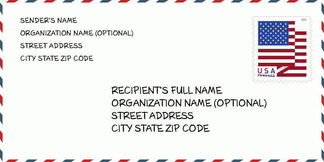
50066-4442封筒の例

-
これは米国の封筒の例です。左上に送信者の情報を入力し、右下に受信者の情報を入力します。必要な情報は、送信者/受信者の氏名、住所、都市、州、および郵便番号です。参照用に受信者のアドレス情報が提供されています。通常、完全な9桁の郵便番号がわからない場合は、パッケージの紛失を防ぐために5桁の郵便番号のみを入力できます。
50066-4442基本的な意味
-
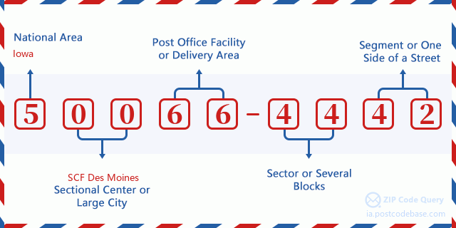
郵便番号50066-4442の各桁は何を表していますか?ZIP + 4コードは2つの部分で構成され、最初の5桁は郵便局に配置でき、最後の4桁は5桁の配達エリア内の地理的セグメントを識別できます。 6〜7桁はセクターまたは複数のブロックを示し、8〜9桁はセグメントまたは通りの片側を示します。

- ·キャリアルートの ID?
A 4-digit code assigned to a mail delivery or collection route within a 5-digit ZIP Code. The first character of this identification is alphabetical, and the last three are numeric: Bnnn = PO box Hnnn = Highway contract Rnnn = Rural route Cnnn = City delivery Gnnn = General delivery: R001 (農村配達ルート)
- ·ZIPアドオンローセクター?
The ZIP Add-On Low Sector and the ZIP Add-On Low Segment together form the ZIP Add-On Low Number. The ZIP Add-On Low Number is the last four positions of a ZIP+4 code; the low-end ZIP add-on in a range of codes; the add-on of the first ZIP+4 code in a consecutive series of ZIP+4 codes assigned to the delivery address. For example, most delivery addresses are assigned a single ZIP+4 code. However, large companies may be given a range of ZIP+4 codes that can be used to route mail to specific departments. A range of ZIP+4 codes can also be assigned to a corresponding range of post office boxes, and each box is mapped, one-to-one, with a ZIP+4 code in the range. A single post office box can also be assigned a range of ZIP+4 codes.: 44
- ·ZIPアドオンローセグメント?
The ZIP Add-On Low Sector and the ZIP Add-On Low Segment together form the ZIP Add-On Low Number. The ZIP Add-On Low Number is the last four positions of a ZIP+4 code; the low-end ZIP add-on in a range of codes; the add-on of the first ZIP+4 code in a consecutive series of ZIP+4 codes assigned to the delivery address. For example, most delivery addresses are assigned a single ZIP+4 code. However, large companies may be given a range of ZIP+4 codes that can be used to route mail to specific departments. A range of ZIP+4 codes can also be assigned to a corresponding range of post office boxes, and each box is mapped, one-to-one, with a ZIP+4 code in the range. A single post office box can also be assigned a range of ZIP+4 codes.: 42
- ·ZIPアドオンハイセクター?
The ZIP Add-On High Sector and the ZIP Add-On High Segment together form the ZIP Add-On High Number, which is the high-end ZIP add-on in a range of codes; the add-on of the last ZIP+4 code in a consecutive series of ZIP+4 codes assigned to the delivery address. Most delivery addresses are assigned a single ZIP+4 code; however, large companies may be given a range of ZIP+4 codes that can be used to route mail to specific departments. A range of ZIP+4 codes can also be assigned to a corresponding range of post office boxes, and each box is mapped, one-to-one, with a ZIP+4 code in the range. A single post office box can also be assigned a range of ZIP+4 codes. (See also ZIP Add-On Code.): 44
- ·ZIPアドオンハイセグメント?
The ZIP Add-On High Sector and the ZIP Add-On High Segment together form the ZIP Add-On High Number, which is the high-end ZIP add-on in a range of codes; the add-on of the last ZIP+4 code in a consecutive series of ZIP+4 codes assigned to the delivery address. Most delivery addresses are assigned a single ZIP+4 code; however, large companies may be given a range of ZIP+4 codes that can be used to route mail to specific departments. A range of ZIP+4 codes can also be assigned to a corresponding range of post office boxes, and each box is mapped, one-to-one, with a ZIP+4 code in the range. A single post office box can also be assigned a range of ZIP+4 codes. (See also ZIP Add-On Code.): 42
- ·郵便番号追加: 4442
- ·範囲?
The range of +4 codes. Summing the +4 Code and the +4 Range will give you the high end of the range of +4 Codes that pertain to this ZIP Code.: 0
- ·基本的な代替コード?
Code that specifies whether a record is a base (preferred) or alternate record. Base records (represented as "B") can represent a range of addresses or an individual address, such as a firm record, while alternate records (represented as "A") are individual delivery points. Government deliveries will only be listed on alternate records with the appropriate government building indicator (federal, state, or city) set.: ベース
- ·ファイナンスナンバー?
A code assigned to Postal Service facilities (primarily post offices) to collect cost and statistical data and compile revenue and expense data. The state number comprises the first two positions of the finance number.: 182250
- ·議会の地区数?
A standard value identifying a geographic area within the United States served by a member of the US House of Representatives or Senate. If Army/Air Force (APO) or fleet post office (FPO), this column will be blank. If there is only one member of Congress within a state, the code will be "AL" (at large).: 03
- ·優先最終行市州キー?
An index to the City State file that provides the preferred last-line name for this address range.: W10375
オンライン地図

これは住所13200 170TH ST, DAWSONに対応するオンライン地図である。地図の中のボタンを利用して移動、拡大・縮小を実現できる。地図情報はただご参考にされて下さい。
アドレス: 13200 (From 13200 To 13299) 170TH ST, DAWSON, IA 50066-4442, USA
コメント


コメントを追加