Adres: 15500 (From 15500 To 15599) C AVE, DAWSON, IA 50066-4448, USA
Co to jest 50066-4448? 50066-4448 to kod pocztowy 5 Plus 4 liczba 15500 (From 15500 To 15599) C AVE, DAWSON, IA, USA. Bliższe informacje poniżej.
50066-4448 Podstawowe informacje

-
Kod Pocztowy 5 Plus 4:
50066-4448 -
Kod Pocztowy 5:
50066 -
Plus 4?44484-digits that are used to identify a geographic segment within the 5-digit delivery area, such as a city block or a group of apartments or an individual high-volume receiver of mail, or any other unit that could use an extra identifier to aid in efficient mail sorting and delivery. This code is the low end of the range of +4 Codes that pertain to this ZIP Code. ZIP+4 Codes associated with nondelivery areas are composed of valid ZIP sector numbers and "ND" for the ZIP segment number, for example 12345-12ND. Non-deliverable areas are areas to which the USPS does not deliver mail, such as vacant lots and land that borders railroad tracks. Mailers should not match an address identified as a nondelivery area. If you absolutely must have numeric characters in the Plus4Code column, you may treat "ND" values as "00" (zero zero).:
-
Kraj:
U.S. - Stany Zjednoczone -
Państwo/stan:
IA - Iowa -
Hrabstwo:
CountyFIPS: 19049 - Dallas County -
Miasto:
DAWSON -
Ulica?C AVEThe official name of a street as assigned by a local governing authority. The Street Name column contains only the street name and does not include directionals (EAST, WEST, etc.) or suffixes (ST, DR, BLVD, etc.). This element may also contain literals, such as PO BOX, GENERAL DELIVERY, USS, PSC, or UNIT. Numeric street names that have numeric components that are four characters (or less) in length at are justified such that the low-order digit of the number is positioned in the fourth position of the street name column. This shift is made so that the numeric street names appear in numeric sequence.:
-
Sufiks Ulicy?AVE (Ulica)The street suffix: For Example: ST = Street RD = Road DR = Drive LN = Lane:
-
Rodzaj Danych?S: UlicaAn alphabetic value that identifies the type of data in the record. Record type codes include the following: G = General delivery H = Highrise F = Firm S = Street P = PO box R = Rural route/highway contract:
Adres

- Prymarny Niski Numer Adresu?
A house, rural route, highway contract box, or post office box number; the numeric or alphanumeric component of an address preceding the street name; the low-end address in a range of addresses. Often referred to as house number.: 15500
- Prymarny Wysoki Numer Adresu?
A house, rural route, contract box, or Post Office box number. The numeric or alphanumeric component of an address preceding the street name. The high-end address in a range of addresses. Often referred to as house number.: 15599
- Nieparzysty/Parzysty Kod Prymarny Adresu?
Code that identifies the side or sides of a street for which a given address range is applicable. For street, highrise, firm and multi-carrier records, B = Both sides of a street, E = Even side of a street (even-numbered addresses in the range); O = Odd side of a street (odd-numbered addresses in the range). For general delivery, post office box, and rural route/highway contract records, this code will always be "B" (both).: Both of Odd and Even
- Podstawowy Zakres: 15500, 15501, 15502, 15503, 15504, 15505, 15506, 15507, 15508, 15509, 15510, 15511, 15512, 15513, 15514, 15515, 15516, 15517, 15518, 15519, 15520, 15521, 15522, 15523, 15524, 15525, 15526, 15527, 15528, 15529, 15530, 15531, 15532, 15533, 15534, 15535, 15536, 15537, 15538, 15539, 15540, 15541, 15542, 15543, 15544, 15545, 15546, 15547, 15548, 15549, 15550, 15551, 15552, 15553, 15554, 15555, 15556, 15557, 15558, 15559, 15560, 15561, 15562, 15563, 15564, 15565, 15566, 15567, 15568, 15569, 15570, 15571, 15572, 15573, 15574, 15575, 15576, 15577, 15578, 15579, 15580, 15581, 15582, 15583, 15584, 15585, 15586, 15587, 15588, 15589, 15590, 15591, 15592, 15593, 15594, 15595, 15596, 15597, 15598, 15599.
Kliknij "Więcej przykładów adresów", aby wyświetlić całą listę.
15500 C AVE, DAWSON, IA 50066-4448
15501 C AVE, DAWSON, IA 50066-4448
15502 C AVE, DAWSON, IA 50066-4448
15503 C AVE, DAWSON, IA 50066-4448
15504 C AVE, DAWSON, IA 50066-4448
15505 C AVE, DAWSON, IA 50066-4448
15506 C AVE, DAWSON, IA 50066-4448
15507 C AVE, DAWSON, IA 50066-4448
15508 C AVE, DAWSON, IA 50066-4448
15509 C AVE, DAWSON, IA 50066-4448
15510 C AVE, DAWSON, IA 50066-4448
15511 C AVE, DAWSON, IA 50066-4448
15512 C AVE, DAWSON, IA 50066-4448
15513 C AVE, DAWSON, IA 50066-4448
15514 C AVE, DAWSON, IA 50066-4448
15515 C AVE, DAWSON, IA 50066-4448
15516 C AVE, DAWSON, IA 50066-4448
15517 C AVE, DAWSON, IA 50066-4448
15518 C AVE, DAWSON, IA 50066-4448
15519 C AVE, DAWSON, IA 50066-4448
15520 C AVE, DAWSON, IA 50066-4448
15521 C AVE, DAWSON, IA 50066-4448
15522 C AVE, DAWSON, IA 50066-4448
15523 C AVE, DAWSON, IA 50066-4448
15524 C AVE, DAWSON, IA 50066-4448
15525 C AVE, DAWSON, IA 50066-4448
15526 C AVE, DAWSON, IA 50066-4448
15527 C AVE, DAWSON, IA 50066-4448
15528 C AVE, DAWSON, IA 50066-4448
15529 C AVE, DAWSON, IA 50066-4448
15530 C AVE, DAWSON, IA 50066-4448
15531 C AVE, DAWSON, IA 50066-4448
15532 C AVE, DAWSON, IA 50066-4448
15533 C AVE, DAWSON, IA 50066-4448
15534 C AVE, DAWSON, IA 50066-4448
15535 C AVE, DAWSON, IA 50066-4448
15536 C AVE, DAWSON, IA 50066-4448
15537 C AVE, DAWSON, IA 50066-4448
15538 C AVE, DAWSON, IA 50066-4448
15539 C AVE, DAWSON, IA 50066-4448
15540 C AVE, DAWSON, IA 50066-4448
15541 C AVE, DAWSON, IA 50066-4448
15542 C AVE, DAWSON, IA 50066-4448
15543 C AVE, DAWSON, IA 50066-4448
15544 C AVE, DAWSON, IA 50066-4448
15545 C AVE, DAWSON, IA 50066-4448
15546 C AVE, DAWSON, IA 50066-4448
15547 C AVE, DAWSON, IA 50066-4448
15548 C AVE, DAWSON, IA 50066-4448
15549 C AVE, DAWSON, IA 50066-4448
15550 C AVE, DAWSON, IA 50066-4448
15551 C AVE, DAWSON, IA 50066-4448
15552 C AVE, DAWSON, IA 50066-4448
15553 C AVE, DAWSON, IA 50066-4448
15554 C AVE, DAWSON, IA 50066-4448
15555 C AVE, DAWSON, IA 50066-4448
15556 C AVE, DAWSON, IA 50066-4448
15557 C AVE, DAWSON, IA 50066-4448
15558 C AVE, DAWSON, IA 50066-4448
15559 C AVE, DAWSON, IA 50066-4448
15560 C AVE, DAWSON, IA 50066-4448
15561 C AVE, DAWSON, IA 50066-4448
15562 C AVE, DAWSON, IA 50066-4448
15563 C AVE, DAWSON, IA 50066-4448
15564 C AVE, DAWSON, IA 50066-4448
15565 C AVE, DAWSON, IA 50066-4448
15566 C AVE, DAWSON, IA 50066-4448
15567 C AVE, DAWSON, IA 50066-4448
15568 C AVE, DAWSON, IA 50066-4448
15569 C AVE, DAWSON, IA 50066-4448
15570 C AVE, DAWSON, IA 50066-4448
15571 C AVE, DAWSON, IA 50066-4448
15572 C AVE, DAWSON, IA 50066-4448
15573 C AVE, DAWSON, IA 50066-4448
15574 C AVE, DAWSON, IA 50066-4448
15575 C AVE, DAWSON, IA 50066-4448
15576 C AVE, DAWSON, IA 50066-4448
15577 C AVE, DAWSON, IA 50066-4448
15578 C AVE, DAWSON, IA 50066-4448
15579 C AVE, DAWSON, IA 50066-4448
15580 C AVE, DAWSON, IA 50066-4448
15581 C AVE, DAWSON, IA 50066-4448
15582 C AVE, DAWSON, IA 50066-4448
15583 C AVE, DAWSON, IA 50066-4448
15584 C AVE, DAWSON, IA 50066-4448
15585 C AVE, DAWSON, IA 50066-4448
15586 C AVE, DAWSON, IA 50066-4448
15587 C AVE, DAWSON, IA 50066-4448
15588 C AVE, DAWSON, IA 50066-4448
15589 C AVE, DAWSON, IA 50066-4448
15590 C AVE, DAWSON, IA 50066-4448
15591 C AVE, DAWSON, IA 50066-4448
15592 C AVE, DAWSON, IA 50066-4448
15593 C AVE, DAWSON, IA 50066-4448
15594 C AVE, DAWSON, IA 50066-4448
15595 C AVE, DAWSON, IA 50066-4448
15596 C AVE, DAWSON, IA 50066-4448
15597 C AVE, DAWSON, IA 50066-4448
15598 C AVE, DAWSON, IA 50066-4448
15599 C AVE, DAWSON, IA 50066-4448
Adres Przykład
DAWSON IA 50066-4448
UNITED STATES OF AMERICA
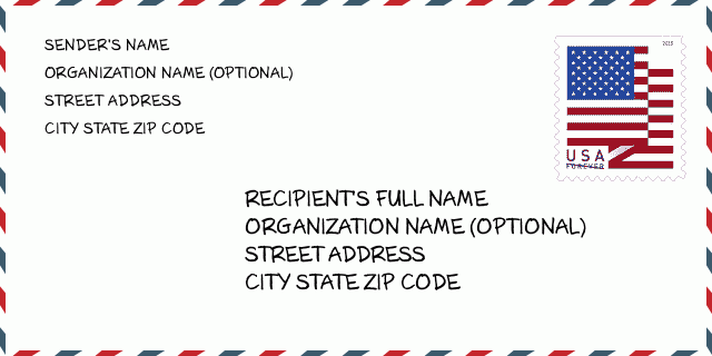
50066-4448 Przykład Koperty

-
To jest przykład koperty amerykańskiej. Wpisz informacje o nadawcy w lewym górnym rogu i informacje o odbiorcy w prawym dolnym rogu. Niezbędne informacje to imię i nazwisko nadawcy/odbiorcy, adres, miasto, województwo i kod pocztowy. Dane adresowe odbiorcy zostały podane w celach informacyjnych. Ogólnie rzecz biorąc, jeśli nie masz pewności co do pełnego 9-cyfrowego kodu pocztowego, możesz wpisać tylko 5-cyfrowy kod pocztowy, aby uniknąć utraty paczki.
50066-4448 Podstawowe znaczenie
-
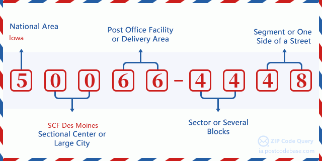
Co oznacza każda cyfra kodu pocztowego 50066-4448? Kod pocztowy + 4 składa się z dwóch części, pierwsze pięć cyfr może znajdować się w urzędzie pocztowym, a ostatnie cztery cyfry mogą identyfikować segment geograficzny w pięciocyfrowym obszarze dostawy. Cyfry 6-7 oznaczają sektor lub kilka bloków, a cyfry 8-9 oznaczają odcinek lub jedną stronę ulicy.

- ·ID Trasy Dostawy?
A 4-digit code assigned to a mail delivery or collection route within a 5-digit ZIP Code. The first character of this identification is alphabetical, and the last three are numeric: Bnnn = PO box Hnnn = Highway contract Rnnn = Rural route Cnnn = City delivery Gnnn = General delivery: R001 (Droga Wiejska)
- ·Sektor Niski ZIP Dodatku?
The ZIP Add-On Low Sector and the ZIP Add-On Low Segment together form the ZIP Add-On Low Number. The ZIP Add-On Low Number is the last four positions of a ZIP+4 code; the low-end ZIP add-on in a range of codes; the add-on of the first ZIP+4 code in a consecutive series of ZIP+4 codes assigned to the delivery address. For example, most delivery addresses are assigned a single ZIP+4 code. However, large companies may be given a range of ZIP+4 codes that can be used to route mail to specific departments. A range of ZIP+4 codes can also be assigned to a corresponding range of post office boxes, and each box is mapped, one-to-one, with a ZIP+4 code in the range. A single post office box can also be assigned a range of ZIP+4 codes.: 44
- ·Segment Niski ZIP Dodatku?
The ZIP Add-On Low Sector and the ZIP Add-On Low Segment together form the ZIP Add-On Low Number. The ZIP Add-On Low Number is the last four positions of a ZIP+4 code; the low-end ZIP add-on in a range of codes; the add-on of the first ZIP+4 code in a consecutive series of ZIP+4 codes assigned to the delivery address. For example, most delivery addresses are assigned a single ZIP+4 code. However, large companies may be given a range of ZIP+4 codes that can be used to route mail to specific departments. A range of ZIP+4 codes can also be assigned to a corresponding range of post office boxes, and each box is mapped, one-to-one, with a ZIP+4 code in the range. A single post office box can also be assigned a range of ZIP+4 codes.: 48
- ·Sektor Wysoki ZIP Dodatku?
The ZIP Add-On High Sector and the ZIP Add-On High Segment together form the ZIP Add-On High Number, which is the high-end ZIP add-on in a range of codes; the add-on of the last ZIP+4 code in a consecutive series of ZIP+4 codes assigned to the delivery address. Most delivery addresses are assigned a single ZIP+4 code; however, large companies may be given a range of ZIP+4 codes that can be used to route mail to specific departments. A range of ZIP+4 codes can also be assigned to a corresponding range of post office boxes, and each box is mapped, one-to-one, with a ZIP+4 code in the range. A single post office box can also be assigned a range of ZIP+4 codes. (See also ZIP Add-On Code.): 44
- ·Segment Wysoki ZIP Dodatku?
The ZIP Add-On High Sector and the ZIP Add-On High Segment together form the ZIP Add-On High Number, which is the high-end ZIP add-on in a range of codes; the add-on of the last ZIP+4 code in a consecutive series of ZIP+4 codes assigned to the delivery address. Most delivery addresses are assigned a single ZIP+4 code; however, large companies may be given a range of ZIP+4 codes that can be used to route mail to specific departments. A range of ZIP+4 codes can also be assigned to a corresponding range of post office boxes, and each box is mapped, one-to-one, with a ZIP+4 code in the range. A single post office box can also be assigned a range of ZIP+4 codes. (See also ZIP Add-On Code.): 48
- ·PNA Dodatek: 4448
- ·Zakres?
The range of +4 codes. Summing the +4 Code and the +4 Range will give you the high end of the range of +4 Codes that pertain to this ZIP Code.: 0
- ·Kod Alternatywny Bazy?
Code that specifies whether a record is a base (preferred) or alternate record. Base records (represented as "B") can represent a range of addresses or an individual address, such as a firm record, while alternate records (represented as "A") are individual delivery points. Government deliveries will only be listed on alternate records with the appropriate government building indicator (federal, state, or city) set.: Baza
- ·Numer Finansowy?
A code assigned to Postal Service facilities (primarily post offices) to collect cost and statistical data and compile revenue and expense data. The state number comprises the first two positions of the finance number.: 182250
- ·Numer Dystryktu Kongresowego?
A standard value identifying a geographic area within the United States served by a member of the US House of Representatives or Senate. If Army/Air Force (APO) or fleet post office (FPO), this column will be blank. If there is only one member of Congress within a state, the code will be "AL" (at large).: 03
- ·Preferowany Klucz Miasta Stanu Ostatniej Linii?
An index to the City State file that provides the preferred last-line name for this address range.: W10375
Mapa

To mapa sieciowa adresu 15500 C AVE, DAWSON. Mapę można przybliżyć. Mapa przeznaczona jest wyłącznie dla celów informacyjnych.
Adres: 15500 (From 15500 To 15599) C AVE, DAWSON, IA 50066-4448, USA
Komentarz


Dodaj komentarz