Adres: 200 (From 200 To 299) BROAD ST, DERBY, IA 50068-7700, USA
Co to jest 50068-7700? 50068-7700 to kod pocztowy 5 Plus 4 liczba 200 (From 200 To 299) BROAD ST, DERBY, IA, USA. Bliższe informacje poniżej.
50068-7700 Podstawowe informacje

-
Kod Pocztowy 5 Plus 4:
50068-7700 -
Kod Pocztowy 5:
50068 -
Plus 4?77004-digits that are used to identify a geographic segment within the 5-digit delivery area, such as a city block or a group of apartments or an individual high-volume receiver of mail, or any other unit that could use an extra identifier to aid in efficient mail sorting and delivery. This code is the low end of the range of +4 Codes that pertain to this ZIP Code. ZIP+4 Codes associated with nondelivery areas are composed of valid ZIP sector numbers and "ND" for the ZIP segment number, for example 12345-12ND. Non-deliverable areas are areas to which the USPS does not deliver mail, such as vacant lots and land that borders railroad tracks. Mailers should not match an address identified as a nondelivery area. If you absolutely must have numeric characters in the Plus4Code column, you may treat "ND" values as "00" (zero zero).:
-
Kraj:
U.S. - Stany Zjednoczone -
Państwo/stan:
IA - Iowa -
Hrabstwo:
CountyFIPS: 19117 - Lucas County -
Miasto:
DERBY -
Ulica?BROAD STThe official name of a street as assigned by a local governing authority. The Street Name column contains only the street name and does not include directionals (EAST, WEST, etc.) or suffixes (ST, DR, BLVD, etc.). This element may also contain literals, such as PO BOX, GENERAL DELIVERY, USS, PSC, or UNIT. Numeric street names that have numeric components that are four characters (or less) in length at are justified such that the low-order digit of the number is positioned in the fourth position of the street name column. This shift is made so that the numeric street names appear in numeric sequence.:
-
Sufiks Ulicy?ST (Ulica)The street suffix: For Example: ST = Street RD = Road DR = Drive LN = Lane:
-
Rodzaj Danych?S: UlicaAn alphabetic value that identifies the type of data in the record. Record type codes include the following: G = General delivery H = Highrise F = Firm S = Street P = PO box R = Rural route/highway contract:
Adres

- Prymarny Niski Numer Adresu?
A house, rural route, highway contract box, or post office box number; the numeric or alphanumeric component of an address preceding the street name; the low-end address in a range of addresses. Often referred to as house number.: 200
- Prymarny Wysoki Numer Adresu?
A house, rural route, contract box, or Post Office box number. The numeric or alphanumeric component of an address preceding the street name. The high-end address in a range of addresses. Often referred to as house number.: 299
- Nieparzysty/Parzysty Kod Prymarny Adresu?
Code that identifies the side or sides of a street for which a given address range is applicable. For street, highrise, firm and multi-carrier records, B = Both sides of a street, E = Even side of a street (even-numbered addresses in the range); O = Odd side of a street (odd-numbered addresses in the range). For general delivery, post office box, and rural route/highway contract records, this code will always be "B" (both).: Both of Odd and Even
- Podstawowy Zakres: 200, 201, 202, 203, 204, 205, 206, 207, 208, 209, 210, 211, 212, 213, 214, 215, 216, 217, 218, 219, 220, 221, 222, 223, 224, 225, 226, 227, 228, 229, 230, 231, 232, 233, 234, 235, 236, 237, 238, 239, 240, 241, 242, 243, 244, 245, 246, 247, 248, 249, 250, 251, 252, 253, 254, 255, 256, 257, 258, 259, 260, 261, 262, 263, 264, 265, 266, 267, 268, 269, 270, 271, 272, 273, 274, 275, 276, 277, 278, 279, 280, 281, 282, 283, 284, 285, 286, 287, 288, 289, 290, 291, 292, 293, 294, 295, 296, 297, 298, 299.
Kliknij "Więcej przykładów adresów", aby wyświetlić całą listę.
200 BROAD ST, DERBY, IA 50068-7700
201 BROAD ST, DERBY, IA 50068-7700
202 BROAD ST, DERBY, IA 50068-7700
203 BROAD ST, DERBY, IA 50068-7700
204 BROAD ST, DERBY, IA 50068-7700
205 BROAD ST, DERBY, IA 50068-7700
206 BROAD ST, DERBY, IA 50068-7700
207 BROAD ST, DERBY, IA 50068-7700
208 BROAD ST, DERBY, IA 50068-7700
209 BROAD ST, DERBY, IA 50068-7700
210 BROAD ST, DERBY, IA 50068-7700
211 BROAD ST, DERBY, IA 50068-7700
212 BROAD ST, DERBY, IA 50068-7700
213 BROAD ST, DERBY, IA 50068-7700
214 BROAD ST, DERBY, IA 50068-7700
215 BROAD ST, DERBY, IA 50068-7700
216 BROAD ST, DERBY, IA 50068-7700
217 BROAD ST, DERBY, IA 50068-7700
218 BROAD ST, DERBY, IA 50068-7700
219 BROAD ST, DERBY, IA 50068-7700
220 BROAD ST, DERBY, IA 50068-7700
221 BROAD ST, DERBY, IA 50068-7700
222 BROAD ST, DERBY, IA 50068-7700
223 BROAD ST, DERBY, IA 50068-7700
224 BROAD ST, DERBY, IA 50068-7700
225 BROAD ST, DERBY, IA 50068-7700
226 BROAD ST, DERBY, IA 50068-7700
227 BROAD ST, DERBY, IA 50068-7700
228 BROAD ST, DERBY, IA 50068-7700
229 BROAD ST, DERBY, IA 50068-7700
230 BROAD ST, DERBY, IA 50068-7700
231 BROAD ST, DERBY, IA 50068-7700
232 BROAD ST, DERBY, IA 50068-7700
233 BROAD ST, DERBY, IA 50068-7700
234 BROAD ST, DERBY, IA 50068-7700
235 BROAD ST, DERBY, IA 50068-7700
236 BROAD ST, DERBY, IA 50068-7700
237 BROAD ST, DERBY, IA 50068-7700
238 BROAD ST, DERBY, IA 50068-7700
239 BROAD ST, DERBY, IA 50068-7700
240 BROAD ST, DERBY, IA 50068-7700
241 BROAD ST, DERBY, IA 50068-7700
242 BROAD ST, DERBY, IA 50068-7700
243 BROAD ST, DERBY, IA 50068-7700
244 BROAD ST, DERBY, IA 50068-7700
245 BROAD ST, DERBY, IA 50068-7700
246 BROAD ST, DERBY, IA 50068-7700
247 BROAD ST, DERBY, IA 50068-7700
248 BROAD ST, DERBY, IA 50068-7700
249 BROAD ST, DERBY, IA 50068-7700
250 BROAD ST, DERBY, IA 50068-7700
251 BROAD ST, DERBY, IA 50068-7700
252 BROAD ST, DERBY, IA 50068-7700
253 BROAD ST, DERBY, IA 50068-7700
254 BROAD ST, DERBY, IA 50068-7700
255 BROAD ST, DERBY, IA 50068-7700
256 BROAD ST, DERBY, IA 50068-7700
257 BROAD ST, DERBY, IA 50068-7700
258 BROAD ST, DERBY, IA 50068-7700
259 BROAD ST, DERBY, IA 50068-7700
260 BROAD ST, DERBY, IA 50068-7700
261 BROAD ST, DERBY, IA 50068-7700
262 BROAD ST, DERBY, IA 50068-7700
263 BROAD ST, DERBY, IA 50068-7700
264 BROAD ST, DERBY, IA 50068-7700
265 BROAD ST, DERBY, IA 50068-7700
266 BROAD ST, DERBY, IA 50068-7700
267 BROAD ST, DERBY, IA 50068-7700
268 BROAD ST, DERBY, IA 50068-7700
269 BROAD ST, DERBY, IA 50068-7700
270 BROAD ST, DERBY, IA 50068-7700
271 BROAD ST, DERBY, IA 50068-7700
272 BROAD ST, DERBY, IA 50068-7700
273 BROAD ST, DERBY, IA 50068-7700
274 BROAD ST, DERBY, IA 50068-7700
275 BROAD ST, DERBY, IA 50068-7700
276 BROAD ST, DERBY, IA 50068-7700
277 BROAD ST, DERBY, IA 50068-7700
278 BROAD ST, DERBY, IA 50068-7700
279 BROAD ST, DERBY, IA 50068-7700
280 BROAD ST, DERBY, IA 50068-7700
281 BROAD ST, DERBY, IA 50068-7700
282 BROAD ST, DERBY, IA 50068-7700
283 BROAD ST, DERBY, IA 50068-7700
284 BROAD ST, DERBY, IA 50068-7700
285 BROAD ST, DERBY, IA 50068-7700
286 BROAD ST, DERBY, IA 50068-7700
287 BROAD ST, DERBY, IA 50068-7700
288 BROAD ST, DERBY, IA 50068-7700
289 BROAD ST, DERBY, IA 50068-7700
290 BROAD ST, DERBY, IA 50068-7700
291 BROAD ST, DERBY, IA 50068-7700
292 BROAD ST, DERBY, IA 50068-7700
293 BROAD ST, DERBY, IA 50068-7700
294 BROAD ST, DERBY, IA 50068-7700
295 BROAD ST, DERBY, IA 50068-7700
296 BROAD ST, DERBY, IA 50068-7700
297 BROAD ST, DERBY, IA 50068-7700
298 BROAD ST, DERBY, IA 50068-7700
299 BROAD ST, DERBY, IA 50068-7700
Adres Przykład
DERBY IA 50068-7700
UNITED STATES OF AMERICA
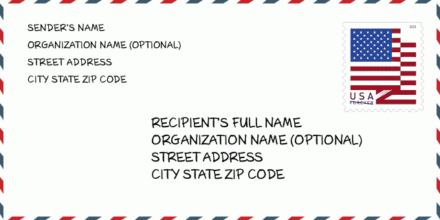
50068-7700 Przykład Koperty

-
To jest przykład koperty amerykańskiej. Wpisz informacje o nadawcy w lewym górnym rogu i informacje o odbiorcy w prawym dolnym rogu. Niezbędne informacje to imię i nazwisko nadawcy/odbiorcy, adres, miasto, województwo i kod pocztowy. Dane adresowe odbiorcy zostały podane w celach informacyjnych. Ogólnie rzecz biorąc, jeśli nie masz pewności co do pełnego 9-cyfrowego kodu pocztowego, możesz wpisać tylko 5-cyfrowy kod pocztowy, aby uniknąć utraty paczki.
50068-7700 Podstawowe znaczenie
-
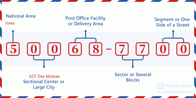
Co oznacza każda cyfra kodu pocztowego 50068-7700? Kod pocztowy + 4 składa się z dwóch części, pierwsze pięć cyfr może znajdować się w urzędzie pocztowym, a ostatnie cztery cyfry mogą identyfikować segment geograficzny w pięciocyfrowym obszarze dostawy. Cyfry 6-7 oznaczają sektor lub kilka bloków, a cyfry 8-9 oznaczają odcinek lub jedną stronę ulicy.

- ·ID Trasy Dostawy?
A 4-digit code assigned to a mail delivery or collection route within a 5-digit ZIP Code. The first character of this identification is alphabetical, and the last three are numeric: Bnnn = PO box Hnnn = Highway contract Rnnn = Rural route Cnnn = City delivery Gnnn = General delivery: R777 (Droga Wiejska)
- ·Sektor Niski ZIP Dodatku?
The ZIP Add-On Low Sector and the ZIP Add-On Low Segment together form the ZIP Add-On Low Number. The ZIP Add-On Low Number is the last four positions of a ZIP+4 code; the low-end ZIP add-on in a range of codes; the add-on of the first ZIP+4 code in a consecutive series of ZIP+4 codes assigned to the delivery address. For example, most delivery addresses are assigned a single ZIP+4 code. However, large companies may be given a range of ZIP+4 codes that can be used to route mail to specific departments. A range of ZIP+4 codes can also be assigned to a corresponding range of post office boxes, and each box is mapped, one-to-one, with a ZIP+4 code in the range. A single post office box can also be assigned a range of ZIP+4 codes.: 77
- ·Segment Niski ZIP Dodatku?
The ZIP Add-On Low Sector and the ZIP Add-On Low Segment together form the ZIP Add-On Low Number. The ZIP Add-On Low Number is the last four positions of a ZIP+4 code; the low-end ZIP add-on in a range of codes; the add-on of the first ZIP+4 code in a consecutive series of ZIP+4 codes assigned to the delivery address. For example, most delivery addresses are assigned a single ZIP+4 code. However, large companies may be given a range of ZIP+4 codes that can be used to route mail to specific departments. A range of ZIP+4 codes can also be assigned to a corresponding range of post office boxes, and each box is mapped, one-to-one, with a ZIP+4 code in the range. A single post office box can also be assigned a range of ZIP+4 codes.: 00
- ·Sektor Wysoki ZIP Dodatku?
The ZIP Add-On High Sector and the ZIP Add-On High Segment together form the ZIP Add-On High Number, which is the high-end ZIP add-on in a range of codes; the add-on of the last ZIP+4 code in a consecutive series of ZIP+4 codes assigned to the delivery address. Most delivery addresses are assigned a single ZIP+4 code; however, large companies may be given a range of ZIP+4 codes that can be used to route mail to specific departments. A range of ZIP+4 codes can also be assigned to a corresponding range of post office boxes, and each box is mapped, one-to-one, with a ZIP+4 code in the range. A single post office box can also be assigned a range of ZIP+4 codes. (See also ZIP Add-On Code.): 77
- ·Segment Wysoki ZIP Dodatku?
The ZIP Add-On High Sector and the ZIP Add-On High Segment together form the ZIP Add-On High Number, which is the high-end ZIP add-on in a range of codes; the add-on of the last ZIP+4 code in a consecutive series of ZIP+4 codes assigned to the delivery address. Most delivery addresses are assigned a single ZIP+4 code; however, large companies may be given a range of ZIP+4 codes that can be used to route mail to specific departments. A range of ZIP+4 codes can also be assigned to a corresponding range of post office boxes, and each box is mapped, one-to-one, with a ZIP+4 code in the range. A single post office box can also be assigned a range of ZIP+4 codes. (See also ZIP Add-On Code.): 00
- ·PNA Dodatek: 7700
- ·Zakres?
The range of +4 codes. Summing the +4 Code and the +4 Range will give you the high end of the range of +4 Codes that pertain to this ZIP Code.: 0
- ·Kod Alternatywny Bazy?
Code that specifies whether a record is a base (preferred) or alternate record. Base records (represented as "B") can represent a range of addresses or an individual address, such as a firm record, while alternate records (represented as "A") are individual delivery points. Government deliveries will only be listed on alternate records with the appropriate government building indicator (federal, state, or city) set.: Baza
- ·Numer Finansowy?
A code assigned to Postal Service facilities (primarily post offices) to collect cost and statistical data and compile revenue and expense data. The state number comprises the first two positions of the finance number.: 182403
- ·Numer Dystryktu Kongresowego?
A standard value identifying a geographic area within the United States served by a member of the US House of Representatives or Senate. If Army/Air Force (APO) or fleet post office (FPO), this column will be blank. If there is only one member of Congress within a state, the code will be "AL" (at large).: 02
- ·Preferowany Klucz Miasta Stanu Ostatniej Linii?
An index to the City State file that provides the preferred last-line name for this address range.: W10399
Mapa

To mapa sieciowa adresu 200 BROAD ST, DERBY. Mapę można przybliżyć. Mapa przeznaczona jest wyłącznie dla celów informacyjnych.
Adres: 200 (From 200 To 299) BROAD ST, DERBY, IA 50068-7700, USA
Komentarz


Dodaj komentarz