ที่อยู่: 1600 (From 1600 To 1699) WATROUS RD, DERBY, IA 50068-8006, USA
50068-8006คืออะไร 50068-8006 เป็นรหัสไปรษณีย์ห้าบวกสี่หลัก 1600 (From 1600 To 1699) WATROUS RD, DERBY, IA, USA มีรายละเอียดดังต่อไปนี้
50068-8006 ข้อมูลพื้นฐาน

-
รหัสไปรษณีย์ 5 พลัส 4:
50068-8006 -
รหัสไปรษณีย์ 5:
50068 -
พลัส 4?80064-digits that are used to identify a geographic segment within the 5-digit delivery area, such as a city block or a group of apartments or an individual high-volume receiver of mail, or any other unit that could use an extra identifier to aid in efficient mail sorting and delivery. This code is the low end of the range of +4 Codes that pertain to this ZIP Code. ZIP+4 Codes associated with nondelivery areas are composed of valid ZIP sector numbers and "ND" for the ZIP segment number, for example 12345-12ND. Non-deliverable areas are areas to which the USPS does not deliver mail, such as vacant lots and land that borders railroad tracks. Mailers should not match an address identified as a nondelivery area. If you absolutely must have numeric characters in the Plus4Code column, you may treat "ND" values as "00" (zero zero).:
-
ประเทศ:
U.S. - ประเทศสหรัฐอเมริกา -
รัฐ:
IA - ไอโอวา -
อำเภอ:
CountyFIPS: 19185 - Wayne County -
เมือง:
DERBY -
ถนน?WATROUS RDThe official name of a street as assigned by a local governing authority. The Street Name column contains only the street name and does not include directionals (EAST, WEST, etc.) or suffixes (ST, DR, BLVD, etc.). This element may also contain literals, such as PO BOX, GENERAL DELIVERY, USS, PSC, or UNIT. Numeric street names that have numeric components that are four characters (or less) in length at are justified such that the low-order digit of the number is positioned in the fourth position of the street name column. This shift is made so that the numeric street names appear in numeric sequence.:
-
คำต่อท้ายถนน ?RD (ถนน)The street suffix: For Example: ST = Street RD = Road DR = Drive LN = Lane:
-
ประเภทระเบียน?S: ถนนAn alphabetic value that identifies the type of data in the record. Record type codes include the following: G = General delivery H = Highrise F = Firm S = Street P = PO box R = Rural route/highway contract:
ที่อยู่

- ตัวเลขหลักต่ำของที่อยู่หลัก?
A house, rural route, highway contract box, or post office box number; the numeric or alphanumeric component of an address preceding the street name; the low-end address in a range of addresses. Often referred to as house number.: 1600
- ตัวเลขหลักสูงของที่อยู่หลัก?
A house, rural route, contract box, or Post Office box number. The numeric or alphanumeric component of an address preceding the street name. The high-end address in a range of addresses. Often referred to as house number.: 1699
- เลขคี่ / เลขคู่ที่อยู่หลัก?
Code that identifies the side or sides of a street for which a given address range is applicable. For street, highrise, firm and multi-carrier records, B = Both sides of a street, E = Even side of a street (even-numbered addresses in the range); O = Odd side of a street (odd-numbered addresses in the range). For general delivery, post office box, and rural route/highway contract records, this code will always be "B" (both).: Both of Odd and Even
- หลัก เทือกเขา: 1600, 1601, 1602, 1603, 1604, 1605, 1606, 1607, 1608, 1609, 1610, 1611, 1612, 1613, 1614, 1615, 1616, 1617, 1618, 1619, 1620, 1621, 1622, 1623, 1624, 1625, 1626, 1627, 1628, 1629, 1630, 1631, 1632, 1633, 1634, 1635, 1636, 1637, 1638, 1639, 1640, 1641, 1642, 1643, 1644, 1645, 1646, 1647, 1648, 1649, 1650, 1651, 1652, 1653, 1654, 1655, 1656, 1657, 1658, 1659, 1660, 1661, 1662, 1663, 1664, 1665, 1666, 1667, 1668, 1669, 1670, 1671, 1672, 1673, 1674, 1675, 1676, 1677, 1678, 1679, 1680, 1681, 1682, 1683, 1684, 1685, 1686, 1687, 1688, 1689, 1690, 1691, 1692, 1693, 1694, 1695, 1696, 1697, 1698, 1699.
โปรดคลิก "ตัวอย่างที่อยู่เพิ่มเติม" เพื่อดูรายการทั้งหมด
1600 WATROUS RD, DERBY, IA 50068-8006
1601 WATROUS RD, DERBY, IA 50068-8006
1602 WATROUS RD, DERBY, IA 50068-8006
1603 WATROUS RD, DERBY, IA 50068-8006
1604 WATROUS RD, DERBY, IA 50068-8006
1605 WATROUS RD, DERBY, IA 50068-8006
1606 WATROUS RD, DERBY, IA 50068-8006
1607 WATROUS RD, DERBY, IA 50068-8006
1608 WATROUS RD, DERBY, IA 50068-8006
1609 WATROUS RD, DERBY, IA 50068-8006
1610 WATROUS RD, DERBY, IA 50068-8006
1611 WATROUS RD, DERBY, IA 50068-8006
1612 WATROUS RD, DERBY, IA 50068-8006
1613 WATROUS RD, DERBY, IA 50068-8006
1614 WATROUS RD, DERBY, IA 50068-8006
1615 WATROUS RD, DERBY, IA 50068-8006
1616 WATROUS RD, DERBY, IA 50068-8006
1617 WATROUS RD, DERBY, IA 50068-8006
1618 WATROUS RD, DERBY, IA 50068-8006
1619 WATROUS RD, DERBY, IA 50068-8006
1620 WATROUS RD, DERBY, IA 50068-8006
1621 WATROUS RD, DERBY, IA 50068-8006
1622 WATROUS RD, DERBY, IA 50068-8006
1623 WATROUS RD, DERBY, IA 50068-8006
1624 WATROUS RD, DERBY, IA 50068-8006
1625 WATROUS RD, DERBY, IA 50068-8006
1626 WATROUS RD, DERBY, IA 50068-8006
1627 WATROUS RD, DERBY, IA 50068-8006
1628 WATROUS RD, DERBY, IA 50068-8006
1629 WATROUS RD, DERBY, IA 50068-8006
1630 WATROUS RD, DERBY, IA 50068-8006
1631 WATROUS RD, DERBY, IA 50068-8006
1632 WATROUS RD, DERBY, IA 50068-8006
1633 WATROUS RD, DERBY, IA 50068-8006
1634 WATROUS RD, DERBY, IA 50068-8006
1635 WATROUS RD, DERBY, IA 50068-8006
1636 WATROUS RD, DERBY, IA 50068-8006
1637 WATROUS RD, DERBY, IA 50068-8006
1638 WATROUS RD, DERBY, IA 50068-8006
1639 WATROUS RD, DERBY, IA 50068-8006
1640 WATROUS RD, DERBY, IA 50068-8006
1641 WATROUS RD, DERBY, IA 50068-8006
1642 WATROUS RD, DERBY, IA 50068-8006
1643 WATROUS RD, DERBY, IA 50068-8006
1644 WATROUS RD, DERBY, IA 50068-8006
1645 WATROUS RD, DERBY, IA 50068-8006
1646 WATROUS RD, DERBY, IA 50068-8006
1647 WATROUS RD, DERBY, IA 50068-8006
1648 WATROUS RD, DERBY, IA 50068-8006
1649 WATROUS RD, DERBY, IA 50068-8006
1650 WATROUS RD, DERBY, IA 50068-8006
1651 WATROUS RD, DERBY, IA 50068-8006
1652 WATROUS RD, DERBY, IA 50068-8006
1653 WATROUS RD, DERBY, IA 50068-8006
1654 WATROUS RD, DERBY, IA 50068-8006
1655 WATROUS RD, DERBY, IA 50068-8006
1656 WATROUS RD, DERBY, IA 50068-8006
1657 WATROUS RD, DERBY, IA 50068-8006
1658 WATROUS RD, DERBY, IA 50068-8006
1659 WATROUS RD, DERBY, IA 50068-8006
1660 WATROUS RD, DERBY, IA 50068-8006
1661 WATROUS RD, DERBY, IA 50068-8006
1662 WATROUS RD, DERBY, IA 50068-8006
1663 WATROUS RD, DERBY, IA 50068-8006
1664 WATROUS RD, DERBY, IA 50068-8006
1665 WATROUS RD, DERBY, IA 50068-8006
1666 WATROUS RD, DERBY, IA 50068-8006
1667 WATROUS RD, DERBY, IA 50068-8006
1668 WATROUS RD, DERBY, IA 50068-8006
1669 WATROUS RD, DERBY, IA 50068-8006
1670 WATROUS RD, DERBY, IA 50068-8006
1671 WATROUS RD, DERBY, IA 50068-8006
1672 WATROUS RD, DERBY, IA 50068-8006
1673 WATROUS RD, DERBY, IA 50068-8006
1674 WATROUS RD, DERBY, IA 50068-8006
1675 WATROUS RD, DERBY, IA 50068-8006
1676 WATROUS RD, DERBY, IA 50068-8006
1677 WATROUS RD, DERBY, IA 50068-8006
1678 WATROUS RD, DERBY, IA 50068-8006
1679 WATROUS RD, DERBY, IA 50068-8006
1680 WATROUS RD, DERBY, IA 50068-8006
1681 WATROUS RD, DERBY, IA 50068-8006
1682 WATROUS RD, DERBY, IA 50068-8006
1683 WATROUS RD, DERBY, IA 50068-8006
1684 WATROUS RD, DERBY, IA 50068-8006
1685 WATROUS RD, DERBY, IA 50068-8006
1686 WATROUS RD, DERBY, IA 50068-8006
1687 WATROUS RD, DERBY, IA 50068-8006
1688 WATROUS RD, DERBY, IA 50068-8006
1689 WATROUS RD, DERBY, IA 50068-8006
1690 WATROUS RD, DERBY, IA 50068-8006
1691 WATROUS RD, DERBY, IA 50068-8006
1692 WATROUS RD, DERBY, IA 50068-8006
1693 WATROUS RD, DERBY, IA 50068-8006
1694 WATROUS RD, DERBY, IA 50068-8006
1695 WATROUS RD, DERBY, IA 50068-8006
1696 WATROUS RD, DERBY, IA 50068-8006
1697 WATROUS RD, DERBY, IA 50068-8006
1698 WATROUS RD, DERBY, IA 50068-8006
1699 WATROUS RD, DERBY, IA 50068-8006
ที่อยู่ ตัวอย่าง
DERBY IA 50068-8006
UNITED STATES OF AMERICA
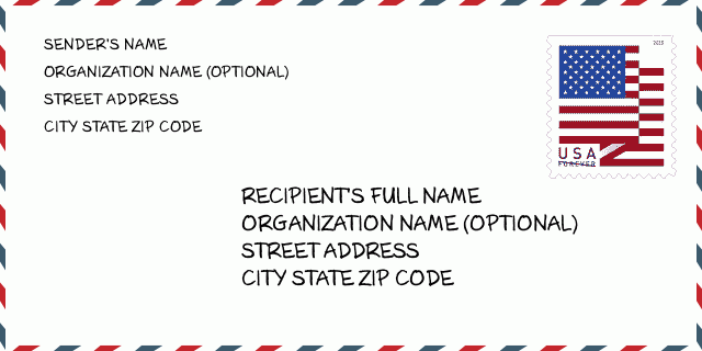
50068-8006 ตัวอย่างซองจดหมาย

-
นี่คือตัวอย่างซองจดหมายของสหรัฐฯ กรอกข้อมูลผู้ส่งที่ด้านบนซ้ายและข้อมูลผู้รับที่ด้านล่างขวา ข้อมูลที่จำเป็นคือชื่อเต็มของผู้ส่ง/ผู้รับ ที่อยู่ เมือง รัฐ และรหัสไปรษณีย์ ข้อมูลที่อยู่ผู้รับได้รับสำหรับการอ้างอิงของคุณ โดยทั่วไป หากคุณไม่แน่ใจเกี่ยวกับรหัสไปรษณีย์ 9 หลักแบบเต็ม คุณสามารถกรอกรหัสไปรษณีย์ 5 หลักเท่านั้นเพื่อหลีกเลี่ยงการสูญหายของพัสดุ
50068-8006 ความหมายพื้นฐาน
-
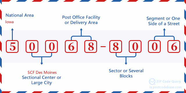
รหัสไปรษณีย์ 50068-8006 แต่ละหลักย่อมาจากอะไร ? รหัสไปรษณีย์ประกอบด้วยสองส่วน โดยสามารถระบุหมายเลขห้าหลักแรกไปยังที่ทำการไปรษณีย์ได้ และตัวเลขสี่หลักสุดท้ายสามารถระบุส่วนทางภูมิศาสตร์ภายในพื้นที่จัดส่งห้าหลักได้ ตัวเลข 6-7 หลักกำหนดส่วนหรือหลายช่วงตึก และตัวเลข 8-9 หลักกำหนดส่วนหรือด้านใดด้านหนึ่งของถนน

- · Idเส้นทางการขนส่ง?
A 4-digit code assigned to a mail delivery or collection route within a 5-digit ZIP Code. The first character of this identification is alphabetical, and the last three are numeric: Bnnn = PO box Hnnn = Highway contract Rnnn = Rural route Cnnn = City delivery Gnnn = General delivery: R002 (สายชนบท)
- ·ภาคต่ำเพิ่มเติมทางไปรษณีย์?
The ZIP Add-On Low Sector and the ZIP Add-On Low Segment together form the ZIP Add-On Low Number. The ZIP Add-On Low Number is the last four positions of a ZIP+4 code; the low-end ZIP add-on in a range of codes; the add-on of the first ZIP+4 code in a consecutive series of ZIP+4 codes assigned to the delivery address. For example, most delivery addresses are assigned a single ZIP+4 code. However, large companies may be given a range of ZIP+4 codes that can be used to route mail to specific departments. A range of ZIP+4 codes can also be assigned to a corresponding range of post office boxes, and each box is mapped, one-to-one, with a ZIP+4 code in the range. A single post office box can also be assigned a range of ZIP+4 codes.: 80
- ·ส่วนต่ำเพิ่มเติมทางไปรษณีย์?
The ZIP Add-On Low Sector and the ZIP Add-On Low Segment together form the ZIP Add-On Low Number. The ZIP Add-On Low Number is the last four positions of a ZIP+4 code; the low-end ZIP add-on in a range of codes; the add-on of the first ZIP+4 code in a consecutive series of ZIP+4 codes assigned to the delivery address. For example, most delivery addresses are assigned a single ZIP+4 code. However, large companies may be given a range of ZIP+4 codes that can be used to route mail to specific departments. A range of ZIP+4 codes can also be assigned to a corresponding range of post office boxes, and each box is mapped, one-to-one, with a ZIP+4 code in the range. A single post office box can also be assigned a range of ZIP+4 codes.: 06
- ·ภาคสูงเพิ่มเติมทางไปรษณีย์?
The ZIP Add-On High Sector and the ZIP Add-On High Segment together form the ZIP Add-On High Number, which is the high-end ZIP add-on in a range of codes; the add-on of the last ZIP+4 code in a consecutive series of ZIP+4 codes assigned to the delivery address. Most delivery addresses are assigned a single ZIP+4 code; however, large companies may be given a range of ZIP+4 codes that can be used to route mail to specific departments. A range of ZIP+4 codes can also be assigned to a corresponding range of post office boxes, and each box is mapped, one-to-one, with a ZIP+4 code in the range. A single post office box can also be assigned a range of ZIP+4 codes. (See also ZIP Add-On Code.): 80
- ·ส่วนสูงเพิ่มเติมทางไปรษณีย์?
The ZIP Add-On High Sector and the ZIP Add-On High Segment together form the ZIP Add-On High Number, which is the high-end ZIP add-on in a range of codes; the add-on of the last ZIP+4 code in a consecutive series of ZIP+4 codes assigned to the delivery address. Most delivery addresses are assigned a single ZIP+4 code; however, large companies may be given a range of ZIP+4 codes that can be used to route mail to specific departments. A range of ZIP+4 codes can also be assigned to a corresponding range of post office boxes, and each box is mapped, one-to-one, with a ZIP+4 code in the range. A single post office box can also be assigned a range of ZIP+4 codes. (See also ZIP Add-On Code.): 06
- ·รหัสไปรษณีย์ เพิ่มเติม: 8006
- ·เทือกเขา?
The range of +4 codes. Summing the +4 Code and the +4 Range will give you the high end of the range of +4 Codes that pertain to this ZIP Code.: 0
- ·รหัสแทนขั้นพื้นฐาน?
Code that specifies whether a record is a base (preferred) or alternate record. Base records (represented as "B") can represent a range of addresses or an individual address, such as a firm record, while alternate records (represented as "A") are individual delivery points. Government deliveries will only be listed on alternate records with the appropriate government building indicator (federal, state, or city) set.: พื้นฐาน
- ·ตัวเลขทางการเงิน?
A code assigned to Postal Service facilities (primarily post offices) to collect cost and statistical data and compile revenue and expense data. The state number comprises the first two positions of the finance number.: 182403
- ·ตัวเลขแขวงรัฐสภา?
A standard value identifying a geographic area within the United States served by a member of the US House of Representatives or Senate. If Army/Air Force (APO) or fleet post office (FPO), this column will be blank. If there is only one member of Congress within a state, the code will be "AL" (at large).: 02
- ·รหัสรัฐเมืองบรรทัดสุดท้าย?
An index to the City State file that provides the preferred last-line name for this address range.: W10399
แผนที่ออนไลน์

นี่คือแผนที่อิเล็กทรอนิกส์ออนไลน์ที่ที่อยู่ 1600 WATROUS RD, DERBYจับคู่นั้น คุณสามารถจะใช้ปุ่มบนแผนที่เพื่อเลื่อนและซูม ข้อมูลแผนที่นี้ เฉพาะสำหรับการอ้างอิงเท่านั้น
ที่อยู่: 1600 (From 1600 To 1699) WATROUS RD, DERBY, IA 50068-8006, USA
ความเห็น


แสดงความเห็น