ที่อยู่: 200 (From 200 To 299) DEERE RD, HUBBARD, IA 50122-7735, USA
50122-7735คืออะไร 50122-7735 เป็นรหัสไปรษณีย์ห้าบวกสี่หลัก 200 (From 200 To 299) DEERE RD, HUBBARD, IA, USA มีรายละเอียดดังต่อไปนี้
50122-7735 ข้อมูลพื้นฐาน

-
รหัสไปรษณีย์ 5 พลัส 4:
50122-7735 -
รหัสไปรษณีย์ 5:
50122 -
พลัส 4?77354-digits that are used to identify a geographic segment within the 5-digit delivery area, such as a city block or a group of apartments or an individual high-volume receiver of mail, or any other unit that could use an extra identifier to aid in efficient mail sorting and delivery. This code is the low end of the range of +4 Codes that pertain to this ZIP Code. ZIP+4 Codes associated with nondelivery areas are composed of valid ZIP sector numbers and "ND" for the ZIP segment number, for example 12345-12ND. Non-deliverable areas are areas to which the USPS does not deliver mail, such as vacant lots and land that borders railroad tracks. Mailers should not match an address identified as a nondelivery area. If you absolutely must have numeric characters in the Plus4Code column, you may treat "ND" values as "00" (zero zero).:
-
ประเทศ:
U.S. - ประเทศสหรัฐอเมริกา -
รัฐ:
IA - ไอโอวา -
อำเภอ:
CountyFIPS: 19083 - Hardin County -
เมือง:
HUBBARD -
ถนน?DEERE RDThe official name of a street as assigned by a local governing authority. The Street Name column contains only the street name and does not include directionals (EAST, WEST, etc.) or suffixes (ST, DR, BLVD, etc.). This element may also contain literals, such as PO BOX, GENERAL DELIVERY, USS, PSC, or UNIT. Numeric street names that have numeric components that are four characters (or less) in length at are justified such that the low-order digit of the number is positioned in the fourth position of the street name column. This shift is made so that the numeric street names appear in numeric sequence.:
-
คำต่อท้ายถนน ?RD (ถนน)The street suffix: For Example: ST = Street RD = Road DR = Drive LN = Lane:
-
ประเภทระเบียน?S: ถนนAn alphabetic value that identifies the type of data in the record. Record type codes include the following: G = General delivery H = Highrise F = Firm S = Street P = PO box R = Rural route/highway contract:
ที่อยู่

- ตัวเลขหลักต่ำของที่อยู่หลัก?
A house, rural route, highway contract box, or post office box number; the numeric or alphanumeric component of an address preceding the street name; the low-end address in a range of addresses. Often referred to as house number.: 200
- ตัวเลขหลักสูงของที่อยู่หลัก?
A house, rural route, contract box, or Post Office box number. The numeric or alphanumeric component of an address preceding the street name. The high-end address in a range of addresses. Often referred to as house number.: 299
- เลขคี่ / เลขคู่ที่อยู่หลัก?
Code that identifies the side or sides of a street for which a given address range is applicable. For street, highrise, firm and multi-carrier records, B = Both sides of a street, E = Even side of a street (even-numbered addresses in the range); O = Odd side of a street (odd-numbered addresses in the range). For general delivery, post office box, and rural route/highway contract records, this code will always be "B" (both).: Both of Odd and Even
- หลัก เทือกเขา: 200, 201, 202, 203, 204, 205, 206, 207, 208, 209, 210, 211, 212, 213, 214, 215, 216, 217, 218, 219, 220, 221, 222, 223, 224, 225, 226, 227, 228, 229, 230, 231, 232, 233, 234, 235, 236, 237, 238, 239, 240, 241, 242, 243, 244, 245, 246, 247, 248, 249, 250, 251, 252, 253, 254, 255, 256, 257, 258, 259, 260, 261, 262, 263, 264, 265, 266, 267, 268, 269, 270, 271, 272, 273, 274, 275, 276, 277, 278, 279, 280, 281, 282, 283, 284, 285, 286, 287, 288, 289, 290, 291, 292, 293, 294, 295, 296, 297, 298, 299.
โปรดคลิก "ตัวอย่างที่อยู่เพิ่มเติม" เพื่อดูรายการทั้งหมด
200 DEERE RD, HUBBARD, IA 50122-7735
201 DEERE RD, HUBBARD, IA 50122-7735
202 DEERE RD, HUBBARD, IA 50122-7735
203 DEERE RD, HUBBARD, IA 50122-7735
204 DEERE RD, HUBBARD, IA 50122-7735
205 DEERE RD, HUBBARD, IA 50122-7735
206 DEERE RD, HUBBARD, IA 50122-7735
207 DEERE RD, HUBBARD, IA 50122-7735
208 DEERE RD, HUBBARD, IA 50122-7735
209 DEERE RD, HUBBARD, IA 50122-7735
210 DEERE RD, HUBBARD, IA 50122-7735
211 DEERE RD, HUBBARD, IA 50122-7735
212 DEERE RD, HUBBARD, IA 50122-7735
213 DEERE RD, HUBBARD, IA 50122-7735
214 DEERE RD, HUBBARD, IA 50122-7735
215 DEERE RD, HUBBARD, IA 50122-7735
216 DEERE RD, HUBBARD, IA 50122-7735
217 DEERE RD, HUBBARD, IA 50122-7735
218 DEERE RD, HUBBARD, IA 50122-7735
219 DEERE RD, HUBBARD, IA 50122-7735
220 DEERE RD, HUBBARD, IA 50122-7735
221 DEERE RD, HUBBARD, IA 50122-7735
222 DEERE RD, HUBBARD, IA 50122-7735
223 DEERE RD, HUBBARD, IA 50122-7735
224 DEERE RD, HUBBARD, IA 50122-7735
225 DEERE RD, HUBBARD, IA 50122-7735
226 DEERE RD, HUBBARD, IA 50122-7735
227 DEERE RD, HUBBARD, IA 50122-7735
228 DEERE RD, HUBBARD, IA 50122-7735
229 DEERE RD, HUBBARD, IA 50122-7735
230 DEERE RD, HUBBARD, IA 50122-7735
231 DEERE RD, HUBBARD, IA 50122-7735
232 DEERE RD, HUBBARD, IA 50122-7735
233 DEERE RD, HUBBARD, IA 50122-7735
234 DEERE RD, HUBBARD, IA 50122-7735
235 DEERE RD, HUBBARD, IA 50122-7735
236 DEERE RD, HUBBARD, IA 50122-7735
237 DEERE RD, HUBBARD, IA 50122-7735
238 DEERE RD, HUBBARD, IA 50122-7735
239 DEERE RD, HUBBARD, IA 50122-7735
240 DEERE RD, HUBBARD, IA 50122-7735
241 DEERE RD, HUBBARD, IA 50122-7735
242 DEERE RD, HUBBARD, IA 50122-7735
243 DEERE RD, HUBBARD, IA 50122-7735
244 DEERE RD, HUBBARD, IA 50122-7735
245 DEERE RD, HUBBARD, IA 50122-7735
246 DEERE RD, HUBBARD, IA 50122-7735
247 DEERE RD, HUBBARD, IA 50122-7735
248 DEERE RD, HUBBARD, IA 50122-7735
249 DEERE RD, HUBBARD, IA 50122-7735
250 DEERE RD, HUBBARD, IA 50122-7735
251 DEERE RD, HUBBARD, IA 50122-7735
252 DEERE RD, HUBBARD, IA 50122-7735
253 DEERE RD, HUBBARD, IA 50122-7735
254 DEERE RD, HUBBARD, IA 50122-7735
255 DEERE RD, HUBBARD, IA 50122-7735
256 DEERE RD, HUBBARD, IA 50122-7735
257 DEERE RD, HUBBARD, IA 50122-7735
258 DEERE RD, HUBBARD, IA 50122-7735
259 DEERE RD, HUBBARD, IA 50122-7735
260 DEERE RD, HUBBARD, IA 50122-7735
261 DEERE RD, HUBBARD, IA 50122-7735
262 DEERE RD, HUBBARD, IA 50122-7735
263 DEERE RD, HUBBARD, IA 50122-7735
264 DEERE RD, HUBBARD, IA 50122-7735
265 DEERE RD, HUBBARD, IA 50122-7735
266 DEERE RD, HUBBARD, IA 50122-7735
267 DEERE RD, HUBBARD, IA 50122-7735
268 DEERE RD, HUBBARD, IA 50122-7735
269 DEERE RD, HUBBARD, IA 50122-7735
270 DEERE RD, HUBBARD, IA 50122-7735
271 DEERE RD, HUBBARD, IA 50122-7735
272 DEERE RD, HUBBARD, IA 50122-7735
273 DEERE RD, HUBBARD, IA 50122-7735
274 DEERE RD, HUBBARD, IA 50122-7735
275 DEERE RD, HUBBARD, IA 50122-7735
276 DEERE RD, HUBBARD, IA 50122-7735
277 DEERE RD, HUBBARD, IA 50122-7735
278 DEERE RD, HUBBARD, IA 50122-7735
279 DEERE RD, HUBBARD, IA 50122-7735
280 DEERE RD, HUBBARD, IA 50122-7735
281 DEERE RD, HUBBARD, IA 50122-7735
282 DEERE RD, HUBBARD, IA 50122-7735
283 DEERE RD, HUBBARD, IA 50122-7735
284 DEERE RD, HUBBARD, IA 50122-7735
285 DEERE RD, HUBBARD, IA 50122-7735
286 DEERE RD, HUBBARD, IA 50122-7735
287 DEERE RD, HUBBARD, IA 50122-7735
288 DEERE RD, HUBBARD, IA 50122-7735
289 DEERE RD, HUBBARD, IA 50122-7735
290 DEERE RD, HUBBARD, IA 50122-7735
291 DEERE RD, HUBBARD, IA 50122-7735
292 DEERE RD, HUBBARD, IA 50122-7735
293 DEERE RD, HUBBARD, IA 50122-7735
294 DEERE RD, HUBBARD, IA 50122-7735
295 DEERE RD, HUBBARD, IA 50122-7735
296 DEERE RD, HUBBARD, IA 50122-7735
297 DEERE RD, HUBBARD, IA 50122-7735
298 DEERE RD, HUBBARD, IA 50122-7735
299 DEERE RD, HUBBARD, IA 50122-7735
ที่อยู่ ตัวอย่าง
HUBBARD IA 50122-7735
UNITED STATES OF AMERICA
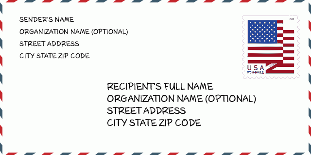
50122-7735 ตัวอย่างซองจดหมาย

-
นี่คือตัวอย่างซองจดหมายของสหรัฐฯ กรอกข้อมูลผู้ส่งที่ด้านบนซ้ายและข้อมูลผู้รับที่ด้านล่างขวา ข้อมูลที่จำเป็นคือชื่อเต็มของผู้ส่ง/ผู้รับ ที่อยู่ เมือง รัฐ และรหัสไปรษณีย์ ข้อมูลที่อยู่ผู้รับได้รับสำหรับการอ้างอิงของคุณ โดยทั่วไป หากคุณไม่แน่ใจเกี่ยวกับรหัสไปรษณีย์ 9 หลักแบบเต็ม คุณสามารถกรอกรหัสไปรษณีย์ 5 หลักเท่านั้นเพื่อหลีกเลี่ยงการสูญหายของพัสดุ
50122-7735 ความหมายพื้นฐาน
-
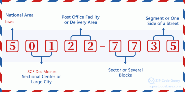
รหัสไปรษณีย์ 50122-7735 แต่ละหลักย่อมาจากอะไร ? รหัสไปรษณีย์ประกอบด้วยสองส่วน โดยสามารถระบุหมายเลขห้าหลักแรกไปยังที่ทำการไปรษณีย์ได้ และตัวเลขสี่หลักสุดท้ายสามารถระบุส่วนทางภูมิศาสตร์ภายในพื้นที่จัดส่งห้าหลักได้ ตัวเลข 6-7 หลักกำหนดส่วนหรือหลายช่วงตึก และตัวเลข 8-9 หลักกำหนดส่วนหรือด้านใดด้านหนึ่งของถนน

- · Idเส้นทางการขนส่ง?
A 4-digit code assigned to a mail delivery or collection route within a 5-digit ZIP Code. The first character of this identification is alphabetical, and the last three are numeric: Bnnn = PO box Hnnn = Highway contract Rnnn = Rural route Cnnn = City delivery Gnnn = General delivery: R777 (สายชนบท)
- ·ภาคต่ำเพิ่มเติมทางไปรษณีย์?
The ZIP Add-On Low Sector and the ZIP Add-On Low Segment together form the ZIP Add-On Low Number. The ZIP Add-On Low Number is the last four positions of a ZIP+4 code; the low-end ZIP add-on in a range of codes; the add-on of the first ZIP+4 code in a consecutive series of ZIP+4 codes assigned to the delivery address. For example, most delivery addresses are assigned a single ZIP+4 code. However, large companies may be given a range of ZIP+4 codes that can be used to route mail to specific departments. A range of ZIP+4 codes can also be assigned to a corresponding range of post office boxes, and each box is mapped, one-to-one, with a ZIP+4 code in the range. A single post office box can also be assigned a range of ZIP+4 codes.: 77
- ·ส่วนต่ำเพิ่มเติมทางไปรษณีย์?
The ZIP Add-On Low Sector and the ZIP Add-On Low Segment together form the ZIP Add-On Low Number. The ZIP Add-On Low Number is the last four positions of a ZIP+4 code; the low-end ZIP add-on in a range of codes; the add-on of the first ZIP+4 code in a consecutive series of ZIP+4 codes assigned to the delivery address. For example, most delivery addresses are assigned a single ZIP+4 code. However, large companies may be given a range of ZIP+4 codes that can be used to route mail to specific departments. A range of ZIP+4 codes can also be assigned to a corresponding range of post office boxes, and each box is mapped, one-to-one, with a ZIP+4 code in the range. A single post office box can also be assigned a range of ZIP+4 codes.: 35
- ·ภาคสูงเพิ่มเติมทางไปรษณีย์?
The ZIP Add-On High Sector and the ZIP Add-On High Segment together form the ZIP Add-On High Number, which is the high-end ZIP add-on in a range of codes; the add-on of the last ZIP+4 code in a consecutive series of ZIP+4 codes assigned to the delivery address. Most delivery addresses are assigned a single ZIP+4 code; however, large companies may be given a range of ZIP+4 codes that can be used to route mail to specific departments. A range of ZIP+4 codes can also be assigned to a corresponding range of post office boxes, and each box is mapped, one-to-one, with a ZIP+4 code in the range. A single post office box can also be assigned a range of ZIP+4 codes. (See also ZIP Add-On Code.): 77
- ·ส่วนสูงเพิ่มเติมทางไปรษณีย์?
The ZIP Add-On High Sector and the ZIP Add-On High Segment together form the ZIP Add-On High Number, which is the high-end ZIP add-on in a range of codes; the add-on of the last ZIP+4 code in a consecutive series of ZIP+4 codes assigned to the delivery address. Most delivery addresses are assigned a single ZIP+4 code; however, large companies may be given a range of ZIP+4 codes that can be used to route mail to specific departments. A range of ZIP+4 codes can also be assigned to a corresponding range of post office boxes, and each box is mapped, one-to-one, with a ZIP+4 code in the range. A single post office box can also be assigned a range of ZIP+4 codes. (See also ZIP Add-On Code.): 35
- ·รหัสไปรษณีย์ เพิ่มเติม: 7735
- ·เทือกเขา?
The range of +4 codes. Summing the +4 Code and the +4 Range will give you the high end of the range of +4 Codes that pertain to this ZIP Code.: 0
- ·รหัสแทนขั้นพื้นฐาน?
Code that specifies whether a record is a base (preferred) or alternate record. Base records (represented as "B") can represent a range of addresses or an individual address, such as a firm record, while alternate records (represented as "A") are individual delivery points. Government deliveries will only be listed on alternate records with the appropriate government building indicator (federal, state, or city) set.: พื้นฐาน
- ·ตัวเลขทางการเงิน?
A code assigned to Postal Service facilities (primarily post offices) to collect cost and statistical data and compile revenue and expense data. The state number comprises the first two positions of the finance number.: 184275
- ·ตัวเลขแขวงรัฐสภา?
A standard value identifying a geographic area within the United States served by a member of the US House of Representatives or Senate. If Army/Air Force (APO) or fleet post office (FPO), this column will be blank. If there is only one member of Congress within a state, the code will be "AL" (at large).: 04
- ·รหัสรัฐเมืองบรรทัดสุดท้าย?
An index to the City State file that provides the preferred last-line name for this address range.: W10720
แผนที่ออนไลน์

นี่คือแผนที่อิเล็กทรอนิกส์ออนไลน์ที่ที่อยู่ 200 DEERE RD, HUBBARDจับคู่นั้น คุณสามารถจะใช้ปุ่มบนแผนที่เพื่อเลื่อนและซูม ข้อมูลแผนที่นี้ เฉพาะสำหรับการอ้างอิงเท่านั้น
ที่อยู่: 200 (From 200 To 299) DEERE RD, HUBBARD, IA 50122-7735, USA
ความเห็น


แสดงความเห็น