Address: 10000 (From 10000 To 10099) 190TH ST, YALE, IA 50277-6006, USA
What's 50277-6006? 50277-6006 is a ZIP Code 5 Plus 4 number of 10000 (From 10000 To 10099) 190TH ST, YALE, IA, USA. Below is detail information.
50277-6006 Basic Information

-
ZIP Code 5 Plus 4:
50277-6006 -
ZIP Code 5:
50277 -
Plus 4?60064-digits that are used to identify a geographic segment within the 5-digit delivery area, such as a city block or a group of apartments or an individual high-volume receiver of mail, or any other unit that could use an extra identifier to aid in efficient mail sorting and delivery. This code is the low end of the range of +4 Codes that pertain to this ZIP Code. ZIP+4 Codes associated with nondelivery areas are composed of valid ZIP sector numbers and "ND" for the ZIP segment number, for example 12345-12ND. Non-deliverable areas are areas to which the USPS does not deliver mail, such as vacant lots and land that borders railroad tracks. Mailers should not match an address identified as a nondelivery area. If you absolutely must have numeric characters in the Plus4Code column, you may treat "ND" values as "00" (zero zero).:
-
Country:
U.S. - United States -
State:
IA - Iowa -
County:
CountyFIPS: 19049 - Dallas County -
City:
YALE -
Street?190TH STThe official name of a street as assigned by a local governing authority. The Street Name column contains only the street name and does not include directionals (EAST, WEST, etc.) or suffixes (ST, DR, BLVD, etc.). This element may also contain literals, such as PO BOX, GENERAL DELIVERY, USS, PSC, or UNIT. Numeric street names that have numeric components that are four characters (or less) in length at are justified such that the low-order digit of the number is positioned in the fourth position of the street name column. This shift is made so that the numeric street names appear in numeric sequence.:
-
Street Suffix?ST (Street)The street suffix: For Example: ST = Street RD = Road DR = Drive LN = Lane:
-
Record Type?S: StreetAn alphabetic value that identifies the type of data in the record. Record type codes include the following: G = General delivery H = Highrise F = Firm S = Street P = PO box R = Rural route/highway contract:
Address

- Address Primary Low Number?
A house, rural route, highway contract box, or post office box number; the numeric or alphanumeric component of an address preceding the street name; the low-end address in a range of addresses. Often referred to as house number.: 10000
- Address Primary High Number?
A house, rural route, contract box, or Post Office box number. The numeric or alphanumeric component of an address preceding the street name. The high-end address in a range of addresses. Often referred to as house number.: 10099
- Address Primary Odd / Even Code?
Code that identifies the side or sides of a street for which a given address range is applicable. For street, highrise, firm and multi-carrier records, B = Both sides of a street, E = Even side of a street (even-numbered addresses in the range); O = Odd side of a street (odd-numbered addresses in the range). For general delivery, post office box, and rural route/highway contract records, this code will always be "B" (both).: Both of Odd and Even
- Primary Range: 10000, 10001, 10002, 10003, 10004, 10005, 10006, 10007, 10008, 10009, 10010, 10011, 10012, 10013, 10014, 10015, 10016, 10017, 10018, 10019, 10020, 10021, 10022, 10023, 10024, 10025, 10026, 10027, 10028, 10029, 10030, 10031, 10032, 10033, 10034, 10035, 10036, 10037, 10038, 10039, 10040, 10041, 10042, 10043, 10044, 10045, 10046, 10047, 10048, 10049, 10050, 10051, 10052, 10053, 10054, 10055, 10056, 10057, 10058, 10059, 10060, 10061, 10062, 10063, 10064, 10065, 10066, 10067, 10068, 10069, 10070, 10071, 10072, 10073, 10074, 10075, 10076, 10077, 10078, 10079, 10080, 10081, 10082, 10083, 10084, 10085, 10086, 10087, 10088, 10089, 10090, 10091, 10092, 10093, 10094, 10095, 10096, 10097, 10098, 10099.
Please click the "More Address Examples" to view the whole list.
10000 190TH ST, YALE, IA 50277-6006
10001 190TH ST, YALE, IA 50277-6006
10002 190TH ST, YALE, IA 50277-6006
10003 190TH ST, YALE, IA 50277-6006
10004 190TH ST, YALE, IA 50277-6006
10005 190TH ST, YALE, IA 50277-6006
10006 190TH ST, YALE, IA 50277-6006
10007 190TH ST, YALE, IA 50277-6006
10008 190TH ST, YALE, IA 50277-6006
10009 190TH ST, YALE, IA 50277-6006
10010 190TH ST, YALE, IA 50277-6006
10011 190TH ST, YALE, IA 50277-6006
10012 190TH ST, YALE, IA 50277-6006
10013 190TH ST, YALE, IA 50277-6006
10014 190TH ST, YALE, IA 50277-6006
10015 190TH ST, YALE, IA 50277-6006
10016 190TH ST, YALE, IA 50277-6006
10017 190TH ST, YALE, IA 50277-6006
10018 190TH ST, YALE, IA 50277-6006
10019 190TH ST, YALE, IA 50277-6006
10020 190TH ST, YALE, IA 50277-6006
10021 190TH ST, YALE, IA 50277-6006
10022 190TH ST, YALE, IA 50277-6006
10023 190TH ST, YALE, IA 50277-6006
10024 190TH ST, YALE, IA 50277-6006
10025 190TH ST, YALE, IA 50277-6006
10026 190TH ST, YALE, IA 50277-6006
10027 190TH ST, YALE, IA 50277-6006
10028 190TH ST, YALE, IA 50277-6006
10029 190TH ST, YALE, IA 50277-6006
10030 190TH ST, YALE, IA 50277-6006
10031 190TH ST, YALE, IA 50277-6006
10032 190TH ST, YALE, IA 50277-6006
10033 190TH ST, YALE, IA 50277-6006
10034 190TH ST, YALE, IA 50277-6006
10035 190TH ST, YALE, IA 50277-6006
10036 190TH ST, YALE, IA 50277-6006
10037 190TH ST, YALE, IA 50277-6006
10038 190TH ST, YALE, IA 50277-6006
10039 190TH ST, YALE, IA 50277-6006
10040 190TH ST, YALE, IA 50277-6006
10041 190TH ST, YALE, IA 50277-6006
10042 190TH ST, YALE, IA 50277-6006
10043 190TH ST, YALE, IA 50277-6006
10044 190TH ST, YALE, IA 50277-6006
10045 190TH ST, YALE, IA 50277-6006
10046 190TH ST, YALE, IA 50277-6006
10047 190TH ST, YALE, IA 50277-6006
10048 190TH ST, YALE, IA 50277-6006
10049 190TH ST, YALE, IA 50277-6006
10050 190TH ST, YALE, IA 50277-6006
10051 190TH ST, YALE, IA 50277-6006
10052 190TH ST, YALE, IA 50277-6006
10053 190TH ST, YALE, IA 50277-6006
10054 190TH ST, YALE, IA 50277-6006
10055 190TH ST, YALE, IA 50277-6006
10056 190TH ST, YALE, IA 50277-6006
10057 190TH ST, YALE, IA 50277-6006
10058 190TH ST, YALE, IA 50277-6006
10059 190TH ST, YALE, IA 50277-6006
10060 190TH ST, YALE, IA 50277-6006
10061 190TH ST, YALE, IA 50277-6006
10062 190TH ST, YALE, IA 50277-6006
10063 190TH ST, YALE, IA 50277-6006
10064 190TH ST, YALE, IA 50277-6006
10065 190TH ST, YALE, IA 50277-6006
10066 190TH ST, YALE, IA 50277-6006
10067 190TH ST, YALE, IA 50277-6006
10068 190TH ST, YALE, IA 50277-6006
10069 190TH ST, YALE, IA 50277-6006
10070 190TH ST, YALE, IA 50277-6006
10071 190TH ST, YALE, IA 50277-6006
10072 190TH ST, YALE, IA 50277-6006
10073 190TH ST, YALE, IA 50277-6006
10074 190TH ST, YALE, IA 50277-6006
10075 190TH ST, YALE, IA 50277-6006
10076 190TH ST, YALE, IA 50277-6006
10077 190TH ST, YALE, IA 50277-6006
10078 190TH ST, YALE, IA 50277-6006
10079 190TH ST, YALE, IA 50277-6006
10080 190TH ST, YALE, IA 50277-6006
10081 190TH ST, YALE, IA 50277-6006
10082 190TH ST, YALE, IA 50277-6006
10083 190TH ST, YALE, IA 50277-6006
10084 190TH ST, YALE, IA 50277-6006
10085 190TH ST, YALE, IA 50277-6006
10086 190TH ST, YALE, IA 50277-6006
10087 190TH ST, YALE, IA 50277-6006
10088 190TH ST, YALE, IA 50277-6006
10089 190TH ST, YALE, IA 50277-6006
10090 190TH ST, YALE, IA 50277-6006
10091 190TH ST, YALE, IA 50277-6006
10092 190TH ST, YALE, IA 50277-6006
10093 190TH ST, YALE, IA 50277-6006
10094 190TH ST, YALE, IA 50277-6006
10095 190TH ST, YALE, IA 50277-6006
10096 190TH ST, YALE, IA 50277-6006
10097 190TH ST, YALE, IA 50277-6006
10098 190TH ST, YALE, IA 50277-6006
10099 190TH ST, YALE, IA 50277-6006
Address Example
YALE IA 50277-6006
UNITED STATES OF AMERICA
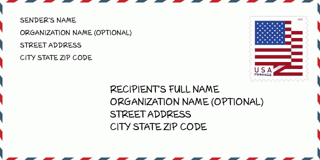
50277-6006 Envelope Example

-
This is an example of U.S envelope. Fill in the sender's information at the top left and the recipient information at the bottom right. The necessary information is sender/recipient's full name, street address, city, state and zip code. The recipient address information has been given for your reference. Generally, If you are not sure of the full 9-digit zip code, you can only fill in the 5-digit zip code to avoid loss of package.
50277-6006 Basic Meaning
-
What does each digit of ZIP Code 50277-6006 stands for? ZIP+4 Code consists of two parts, the first five digits can be located to the post office, and the last four digits can identify a geographic segment within the five-digit delivery area. The 6-7 digits designate sector or several blocks, and the 8-9 digits designate segment or one side of a street.
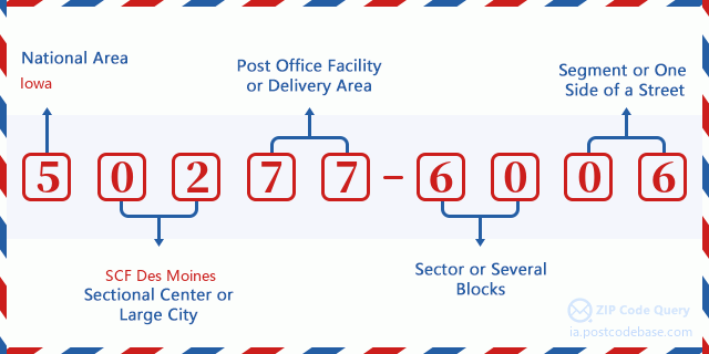

- ·Carrier Route ID?
A 4-digit code assigned to a mail delivery or collection route within a 5-digit ZIP Code. The first character of this identification is alphabetical, and the last three are numeric: Bnnn = PO box Hnnn = Highway contract Rnnn = Rural route Cnnn = City delivery Gnnn = General delivery: R001 (Rural route)
- ·ZIP Add-On Low Sector?
The ZIP Add-On Low Sector and the ZIP Add-On Low Segment together form the ZIP Add-On Low Number. The ZIP Add-On Low Number is the last four positions of a ZIP+4 code; the low-end ZIP add-on in a range of codes; the add-on of the first ZIP+4 code in a consecutive series of ZIP+4 codes assigned to the delivery address. For example, most delivery addresses are assigned a single ZIP+4 code. However, large companies may be given a range of ZIP+4 codes that can be used to route mail to specific departments. A range of ZIP+4 codes can also be assigned to a corresponding range of post office boxes, and each box is mapped, one-to-one, with a ZIP+4 code in the range. A single post office box can also be assigned a range of ZIP+4 codes.: 60
- ·ZIP Add-On Low Segment?
The ZIP Add-On Low Sector and the ZIP Add-On Low Segment together form the ZIP Add-On Low Number. The ZIP Add-On Low Number is the last four positions of a ZIP+4 code; the low-end ZIP add-on in a range of codes; the add-on of the first ZIP+4 code in a consecutive series of ZIP+4 codes assigned to the delivery address. For example, most delivery addresses are assigned a single ZIP+4 code. However, large companies may be given a range of ZIP+4 codes that can be used to route mail to specific departments. A range of ZIP+4 codes can also be assigned to a corresponding range of post office boxes, and each box is mapped, one-to-one, with a ZIP+4 code in the range. A single post office box can also be assigned a range of ZIP+4 codes.: 06
- ·ZIP Add-On High Sector?
The ZIP Add-On High Sector and the ZIP Add-On High Segment together form the ZIP Add-On High Number, which is the high-end ZIP add-on in a range of codes; the add-on of the last ZIP+4 code in a consecutive series of ZIP+4 codes assigned to the delivery address. Most delivery addresses are assigned a single ZIP+4 code; however, large companies may be given a range of ZIP+4 codes that can be used to route mail to specific departments. A range of ZIP+4 codes can also be assigned to a corresponding range of post office boxes, and each box is mapped, one-to-one, with a ZIP+4 code in the range. A single post office box can also be assigned a range of ZIP+4 codes. (See also ZIP Add-On Code.): 60
- ·ZIP Add-On High Segment?
The ZIP Add-On High Sector and the ZIP Add-On High Segment together form the ZIP Add-On High Number, which is the high-end ZIP add-on in a range of codes; the add-on of the last ZIP+4 code in a consecutive series of ZIP+4 codes assigned to the delivery address. Most delivery addresses are assigned a single ZIP+4 code; however, large companies may be given a range of ZIP+4 codes that can be used to route mail to specific departments. A range of ZIP+4 codes can also be assigned to a corresponding range of post office boxes, and each box is mapped, one-to-one, with a ZIP+4 code in the range. A single post office box can also be assigned a range of ZIP+4 codes. (See also ZIP Add-On Code.): 06
- ·ZIP Code Add On: 6006
- ·Range?
The range of +4 codes. Summing the +4 Code and the +4 Range will give you the high end of the range of +4 Codes that pertain to this ZIP Code.: 0
- ·Base Alternate Code?
Code that specifies whether a record is a base (preferred) or alternate record. Base records (represented as "B") can represent a range of addresses or an individual address, such as a firm record, while alternate records (represented as "A") are individual delivery points. Government deliveries will only be listed on alternate records with the appropriate government building indicator (federal, state, or city) set.: Base
- ·Finance Number?
A code assigned to Postal Service facilities (primarily post offices) to collect cost and statistical data and compile revenue and expense data. The state number comprises the first two positions of the finance number.: 189873
- ·Congressional District Number?
A standard value identifying a geographic area within the United States served by a member of the US House of Representatives or Senate. If Army/Air Force (APO) or fleet post office (FPO), this column will be blank. If there is only one member of Congress within a state, the code will be "AL" (at large).: 03
- ·Preferred Last Line City State Key?
An index to the City State file that provides the preferred last-line name for this address range.: W11782
Online Map

This is online map of the address 10000 190TH ST, YALE. You may use button to move and zoom in / out. The map information is for reference only.
Address: 10000 (From 10000 To 10099) 190TH ST, YALE, IA 50277-6006, USA
Comment


Add new comment